The architecture of places of worship in Asia is an expression of the way of thinking in much the same way as elsewhere in the world. However, to cover the whole field of religion and architecture – even if it is narrowed down to the four-fold – is a Herculean task, which cannot be performed in a single chapter of a book. Both entities (Eastern religion and architecture) are so diverse and varied that even a brief survey would do no justice to the immense field of various beliefs and the material expressions thereof in architecture.
The easiest solution to scale this mountain of relevant information would be to abandon the operation right from the very start and leave the chapter on ‘eastern’ tetradic architecture completely out of this book. Some promise could be made to cover the subject another time in a separate book. However, to leave such an important contribution to the field of investigation out of the present survey would be unacceptable too. So a compromise had to be made and only some of the most outstanding examples of tetradic (temple) architecture in Asia are singled out for a short review, without a deeper quest for their religious and/or philosophical background and with no intention to be exhaustive.
A temple might be built for the primary purpose of worship, but it also demands a wider reading in relation to its material presence. It can function as object of devotion, as a mean to construct a personal reality, as a proof of power, and – last but not least – it can point to the state of mind of the architects, who designed the building in line with its spiritual purpose. This latter, psychological reading is of particular interest in the present investigation. It is well known that the building of sanctuaries was inspired by the symbolism of the religion, but also provided the visible enhancement of that symbolism in a practical way.
The Hindu world view is based on a cycle of creation to destruction, which is divided into four ages (yugas). According to the Indian view, the universe is destroyed by fire and subsequently dissolved into a cosmic ocean out of which a new universe is created and another era begins (MICHEL, 1977). Man’s position in this cycle is like a spell or illusion (maya), which should be broken (in a release or moksha) to understand the reality behind it. Geometric considerations occupy an important place in Hindu thoughts. Number is seen as a mean to express the relation between man and the universe. Indian temple architecture as a whole is greatly inspired by proportional measurements and dimensions.
The holy Mount Meru stands in the center of the universe and is the axis of the world (fig. 127). The sanctuary as a whole is called a vimana, which means ‘well-measured’ or ‘well-proportioned’. The pyramidal or tapering roof above the vimana is called the shikhara and is a representation of Mount Meru. The Brihatsamhita was an early treatise on astrology, which also included a chapter on temple building. Time is of essence and the cardinal points have a symbolic meaning, with a major orientation along an east-west axis. The mountain Kailash (6714 meters) in western Tibet is regarded by many believers as the representation of Mount Meru on earth and as the central axis of a spiritual universe.
Vaastu Shastra deals with the knowledge and principles of the physical environment. It exerts an all-embracing influence on the traditional Hindu architecture. This knowledge was written down in three major texts. The Viswakarma vaastushastra has a North Indian origin. The Manasara Silpa Shastra and the Mayamatam are derived from Southern India. The latter (Dravidian) text concluded that ‘if the measurements of the temple are in every way perfect, there will be perfection in the universe as well.’
Fig. 127 – Mount Meru is seen here at the center of a quaternary scheme of the world (Gouache on cotton, eighteenth century, Rajasthan, West India).
The mandala is a central entity in Hinduism and Buddhism and is the generic name for any plan or chart, which represents the cosmos (MICHEL, 1977). In Sanskrit mandala means ‘circle and center’ or ‘Holy Circle’ and points to its cyclic character. This circle is often embedded in a square, being a symbolic rendering of the surface of the earth (Prithvi). The earth is ‘Caturbhsti’ or ‘four cornered’.
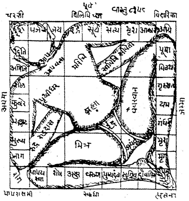
The Vaasta Purusha mandala is a specific type of mandala used in Vaastu Shastra, representing a metaphysical plan of a building or temple in relation to the course of the heavenly bodies and supernatural forces. Purusha refers to the energy and power, which is generated by the understanding of this cosmic presence. The form is a square, subdivided in smaller squares. The number of subdivisions can vary and each type has a distinct name and is used in a specific context. The central area is called the Brahma-sthana, because Brahma or some other prominent deity concerned with the creation usually occupies it. The building (of a temple) takes place from a chosen grid, dedicated to a particular deity. Planetary divinities are arranged around the Bramasthana. The central place, being the most important part of the building, remains unbuilt (fig. 128).
Fig. 128 – The cosmic man or mahapurusha, drawn on a temple mandala indicates the relation between parts of the body and the meaning of its position within the architectonic setting. The outlay of a temple is subject to the principle of vimana, meaning ‘well-measured’ or ‘well-proportioned’. This picture is derived from an ancient manual of architecture. The main axis runs here from south-east to north west (head), but an orientation from south-west to north-east is also known.
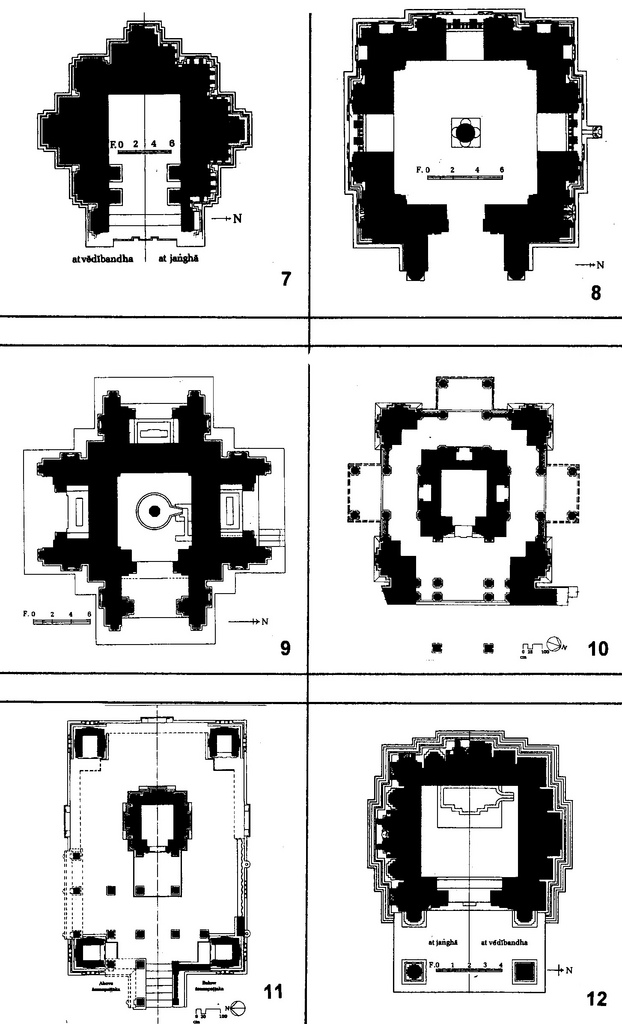
The ‘Encyclopaedia of Indian Temple Architecture’ by Michael MEISTER (1988/1991) is a treasure house of descriptions and ground plans of temples and temple complexes in northern and southern India. Even a superficial glance of the books will leave an impression of the richness and exuberance of Indian temple architecture (fig. 129/130). It would lead much too far to go into detail of the styles in time and place, but one important conclusion can be drawn just by looking through Meister’s encyclopedia: the Indian temple architecture, both in its northern and southern variety, are deeply inspired by a tetradic consciousness.
The square and rectangular outlay, if possible orientated along an east-west axis, with the entrance to the east, is the main characteristic. In front of the doorway is often a pillared hall, or mandapa. The attention to the four directions, either in the form of entrances or stairs, is prominent.
Fig. 129 – An axonometric drawing of the Rajivalocana temple at Rajim (Chhattisgarth, forty-five kilometers southeast of Raipur) shows the variance on the tetradic theme. The temple dated from around A.D. 600 and is dedicated to Lord Vishnu.
Fig. 130A – A variety of Indian temples indicating a preference for a tetradic setting. 1. Shiva’s temple in Fathgadh (Fatehgarh, Kashmir); 2. Savarinarayana temple in Kharod; 3. Jaikamath in Barwasagar (Jhansi, Uttar Pradesh); 4. Suraya temple in Madkheda (Madhya Pradesh); 5. Svarnajalesvara temple at Bhuvanes-vara (Bhubaneswar, Orissa); 6. Huccapayya temple in Aihole (the ‘Cradle of Indian Architecture’; Karnataka, near Begalkot).
Fig. 130B – A variety of Indian temples indicating a preference for the tetradic setting. 7. Shiva temple in Binaika (near Sagar, Madhya Pradesh); 8. Caturmukha (‘four-faced’) Mahadeva temple in Nacna; 9. Basesar Mahadeva temple in Bajaura (Kullu; Himachal Pradesh); 10. Mahadeva temple in Bithu; 11. Harihara temple no. 2 in Osian (Jodhpur, Rajasthan); 12. Naktimata temple in Bhavanipur (Uttar Pradesh).
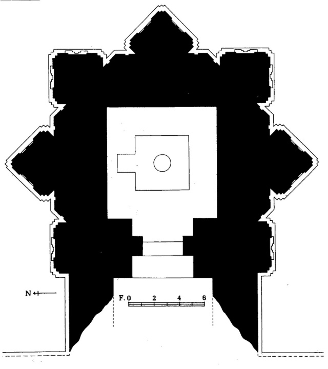
LEONARDIS (2002) pointed, in a detailed description of the plan of the S. Sofia church in Benevento (Italy, see p. 329ff), to the ground plan of two temples in northern India, with a rotated square as a design tool. The Siva Temple at Adbhar and the Dhobini temple (fig. 131) dated from around 700 AD. They were only slightly earlier than the building of the S. Sofia in Benevento around 760 AD. It is unlikely that any direct influence was communicated over such geographical distances, but the conclusion is warranted that similar (tetradic) ideas could lead to resembling architectonic solutions.
Fig. 131 – A plan of the temple at Dhobini, southwest of Damakheda (sixty kilometers south west of Bilaspur), a pilgrim center for the religious sect of the Kabirapanthis. The outlay of the temple is – in the same way as in the Siva temple in Adbhar – designed by placing two squares at an angle of forty-five degrees.
The temple of Sri Venkatesware, near the town of Tirupati in Southern India (Andhra Pradesh), is a fine example of the use of Vaasthu Shastra in religious building in India. The temple is situated on one of the seven hills, called Tirumala or ‘sacred hill’ and regarded as one of the richest temples in the world. The cupola over the sanctum sanctorum of the temple is gold plated. Some fifty thousand pilgrims visit the place every day and are thereby probably eclipsing Rome, Jerusalem and Mecca as far as the numbers of visitors are concerned.
The Brihadeshwara Temple at Thanjavur (Tanjore) is another famous temple, dating from the Cholas Period (900 – 1155 AD), when temple architecture reached its climax in Southern India. The temple is dedicated to Lord Shiva and built in the tenth century by Raja Raja Choila. The temple is capped by a monolithic cupola weighting 81.3 tonnes. Within the shrine is the gigantic Mahalingam, the phallic symbol denoting the primeval energy of the Creator.
Many more examples can be given of Indian temples with tetradic features. There is little doubt that the four-fold had a prominent place in Hindu temple architecture. This observation has to be placed – just like the Roman Catholic cathedral building in Europe during the Middle Ages – in the context of time and place. It is not enough to point to certain tetradic features to draw conclusions about a cultural and/or religious state of mind. Architecture has to be place in a full specter of a historical consciousness. Further study of the Hindu and Buddhist architecture within other fields of human visibilities is therefore required, but cannot be done within the present book.
David LOY (1988) distinguished the nonduality (of subject and object) as a major characteristic of (Advaita) Vedanta, (Mahayana) Buddhism, and Taoism. He elaborated on this theme by placing division thinking in a wider context, but without mentioning the four-fold as an option. Quadralectic thinking is, undoubtedly, a non-dualistic experience and has an immediate interest in the philosophical treatment of this theme.
Nonduality is a major characteristic of the philosophical traditions of India and China and is associated with a non-dual perception, which seemed to be more prominent in the Eastern mind than in its Western counterpart (this suggestion is in itself an obvious duality!). ‘The non-dualistic perspective can understand the dualistic experience, but not vice versa’ is an observation (by Loy), which is directly related to the quadralectic rule that every (revolving) communication is limited by the division-type of the ‘smallest part’ participating in the interaction. The non-dualistic perspective of Mahayana Buddhism and Advaita Vedanta is reflected in the (temple) architecture resulting from this world view.
Buddhism began as an offspring of Hinduism in India in the sixth century BC. The founder of the creed was Siddhartha Gautama, who must have lived around 560 BC in northern India. His life is clouded in myths, but his decision to change his life was taken after he saw four things: an old man, a sick man, a dead man and an ascetic. He decided to start a quest to find the answer to the problem of pain and suffering. In his life of meditation, he found the Four Noble Truths (indicating the way of salvation):
———– 1. There is pain and suffering in the world
———– 2. The cause of suffering is desire
———– 3. The suffering will cease when desire stops
———– 4. To extinguishing all desire is to follow the Eighth-fold Path
In this road to salvation Gautama became a Buddha, the ‘enlightened one’.
Buddha’s teachings spread all over India and Southeast Asia during the reign of Emperor Asoka (third century BC). The earliest written texts (canon) of his life are known as the Pali Canon or ‘Theravada’. The ‘historical’ school of Buddhism, which followed the ‘Doctrine of the Elders’, is called Theravada or Hinyana Buddhism (or Lesser Vehicle).
Buddha’s teachings were systematically arranged and organized into three basic divisions known as ‘Tipitaka’ (or three baskets).
- The basket of discipline deals with rules and customs of the Sangha (the community of monks and followers);
- The basket of discourses contains sermons by the Buddha and his close disciples and
- The basket of higher or special doctrine gives a philosophical and psychological analysis of the Dharma (the eternal and impersonal Law).
A further tribute to the three-division in Buddhism is found in the so-called ‘Three Jewels’:
1. The Buddha,
2. The Dharma (Law) and
3. The Sangha (Community).
The main virtues are compassion, moderation and humility. This Theravada Buddhism stressed monasticism and avoided belief in a god. The emphasis is on self-salvation. The creed moved to the east and survived in Sri Lanka, Thailand and south east Asia and is called ‘Southern Buddhism’.
A more liberal type of doctrine changed the conservative-monastic Buddhist teachings in the second century AD. The idea of a Bodhisattva (being of wisdom) was developed: a ‘saint’, who is qualified to achieve the highest Buddha-nature (Nirwana), but voluntarily stays behind in a cycle of rebirth to help the rest of us.
A further innovation was called the Middle-Way (Madhya-mika), aiming at a cultivation of an inner tranquility by maintaining the balance between the extremes of self-indulgence and self-mortification. These teachings became known as Mahayana Buddhism (or Greater Vehicle). Its imagery appealed to a growing number of people in Afghanistan, India, Kashmir and Central Asia (in the third century), to China (fourth century), Nepal (fifth century) and subsequently in Korea and Japan (sixth century). The major migration northward is known as ‘Northern Buddhism’.
Two additional practices developed in India. Tantrayoga was a system of yoga practices, which had originally no ties with Buddhism and consisted of ‘secret’ knowledge of an esoteric nature. Tantrayoga joined with Buddhism in the six century AD to form a new branch of Mahayana Buddhism called Tantryana. The doctrine was written in Tantric Sutras. The emphasis was directed towards the opposition between micro- (interior world) and macrocosmos (exterior world), the escape from dualities into a multiplicity of opposites, the acceptance of an all-embracing Absolute in which the multiplicities and polarities unify and ultimately a salvation in the unification of opposites.
The way to salvation, which is an essential aim in Tantryana Buddhism, can be found in meditation techniques, using the five senses. In particular the visual stimuli are experienced in a specter of macrocosmic personifications, represented in mandalas and thankas.
The five Djani-buddhas were part of a system of meditation exercises called Vajrayana. The name Vajrayana is derived from the emblem of the fifth Djanibuddha (Vairocana), which was a thunderbolt (or vajra in Sanskrit). The flash of lightning symbolizes the speed and clarity of insight (OLSCHAK & WANGYAL, 1973). The Vishva-Vajra emblem is composed of two crossed vajras, pointing to the tantric symbol of indestructible essence of the appearances and the diamond-clear truth. The higher intentions of the fivefold (division) and the real consciousness of the four-fold (division) join their forces in the graphic and artistic manifestation of the Vishva-Vajra (fig. 132).
Fig. 132 – The Vishva-Vajra is the emblem of the fifth Djanibuddha (Vairocana). The two crossed thunderbolts (vajra) of this tantric symbol represents the indestructible truth.
The first appearances of Djanibuddhas in print dated from the early eighth century in Gansu (China). Tantryana Buddhism reached its zenith in Kashmir. This location at the crossroads of China, India and the West was a center of trade and exchange of ideas. The ‘basic’ Indian Buddhism and yoga were exposed to Iranian Manicheism, Nestorian Christianity and Chinese Taoism. This amalgam of beliefs entered Tibet, which had itself a history of animistic practices. The original shamanistic belief was called Bön and originated, according to tradition, in Iran (and not India).
The painted two-dimensional mandala, which appeared in the eighth and ninth century AD with the rise of the Vajrayana, became the major iconic image of Tibetan Buddhism. Its area of influence covered Tibet, Nepal, Bhutan, Mongolia and northwestern China (fig. 133).
Fig. 133 – A gouache of a Kalachakra mandala with Mount Meru as the center of the world (Tibet, eighteenth century).
Everything in the Kalachakra mandala is a representation of some aspect of the deity and the universe. The word kalachakra means cycles of time (Wheel of Time). The Kalachakra Tantra consists of three such cycles.
1. External (laws of time and space, macrocosmos),
2. Internal (the elements and structure of the human body, micro-cosmos) and
3. Alternative (the doctrine of the meditational deity and its mandala, liberation).
Mandala’s in Tibet are often made of colored sand and later destroyed as a lesson about the impermanence of life. Believers use the painstaking creation of the sand-mandala as an exercise to visualize, in meditation and reality, the steps along the ‘Path of Enlightenment’.
The mandala found its expression in architecture, in particular in relation with the ground plan. The tetradic ground plan became the messenger of an ideal representation of building-in-general (the universe). The four-fold was lifted from its earthly dimensions into a cosmic awareness.
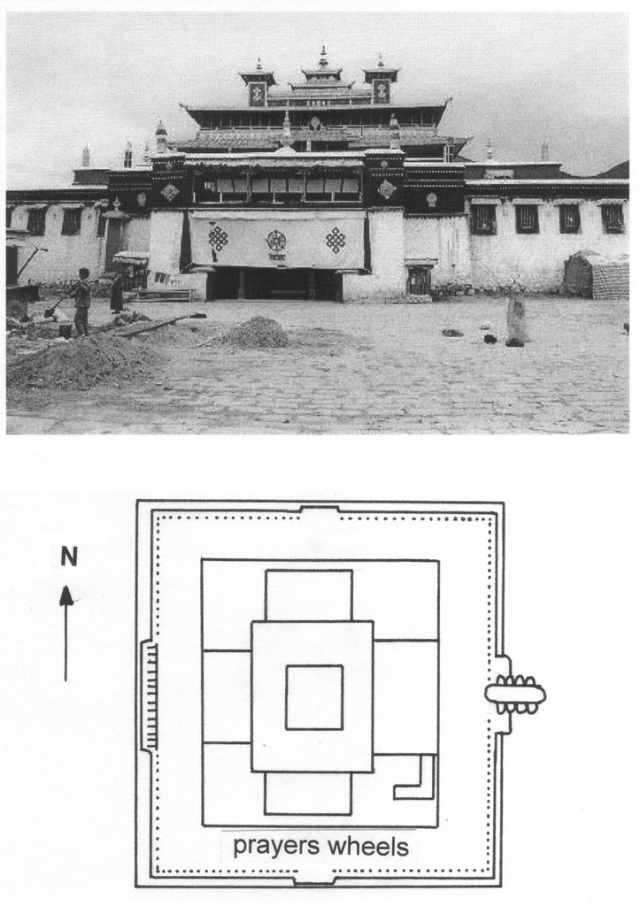
The Tibetan sanctuary of Samye Gompa, founded around 800 AD by King Tresong Detsen and guru Padmasambhava, is an example of the mixture of a mandala and a tetradic design (fig. 134). The central temple represents Mount Meru, while the surrounding temples are visualizations of the oceans and continents that encircle the sacred mountain.
Fig. 134 – The Tibetan sanctuary of Samye Gompa is a monastic complex with the ground plan of a mandala.
The southern branch of the Silk Road was less used in the fourth and fifth century because of drought. The isolation of this part of central Asia resulted in a characteristic brand of Buddhism, before the influence of the Islam (KLIMKEIT (1988). The sanctuary of Rawak, in the desert north east of Khotan, was a perfect Buddhist building. Its mandala design can still be recognized in its present ruinous state (fig. 135).
Fig. 135 – The Stupa of Rawak near Khotan represented a mandala. Khotan was one of the important places on the Silk Road. Marco Polo visited the city at the end of the thirteenth century.
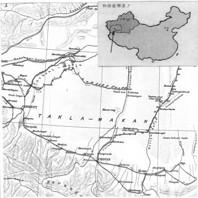
The Swedish explorer Sven Hedin (1865 – 1952) discovered the ‘Pompeji der Wüste’ after he left Khotan (Chotan) on the 14th of January 1896 with a party of four man, three camels and two donkeys (in order to test the latter’s endurance in an extended desert march). They followed the track to the north and rested at the village of Tavek-kel (HEDIN, 1919; II, p. 44). From here they went eastwards into the desert and crossed the sand dunes to a place called Takla-makan (which is also the name for the western extension of the Gobi Desert). Hedin indicated this place on the map as ‘Ruinen einer alten Stadt’ (fig. 136).
Fig. 136 – This map in the travelogue by Sven Hedin (Band II) gives the position of Chotan and his discoveries in the Takla-makan Desert. He indicated the same name (Takla-makan) to the ‘Ruinen einer alten Stadt’, east of Tavekk-kel, where he found ancient writings (‘Papier’), small Buddha statues and kitchen utensils. The place was five years later identified by Aurel Stein as Dandan-Uiliq and yielded much more antiquarian material.
The ruins of a complete city, later called Dandan-Uiliq, were buried in the sand. Hedin and his men did some diggings in houses with a square ground plan. He mentioned in his book the paintings on the walls of a house, showing kneeling women, with their hands folded as in praying and men, who were dressed like the Persians (fig. 137). Furthermore, dogs, horses and boats (!) were depicted. Hedin did not mention any stupa, although there was a house, which was called by his guides the ‘Bud-chane’ (Buddha temple).
Fig. 137 – The house with the painted walls as Sven Hedin found it on the 23rd of January 1896 in the sand-covered city of Takla-makan.
Hedin made an estimate with regards to the age of the sand-buried city, by using the speed of the moving sand dunes as an indication (HEDIN, 1919; Band II, p. 49). With a yearly movement in a southern direction of about fifty meters, he calculated an age of some thousand years for the ruins. However, the predominantly southwestern direction would make the total fifteen hundred years, and he added (?) some five hundred years for winds from the opposite direction. Therefore, the city of Takla-makan dated, in Hedin’s rough estimate, from the first century BC.
The Hungarian-born explorer Aurel Stein (1862 – 1943) and his team followed the tracks of Hedin some five years later (1900-1901). The description of the wanderings around Khotan and the subsequent discovery of the stupa of Rawak as ‘by far the most imposing structure I had seen among the extant ruins in the Khotan region’, reads like an adventure story (STEIN, 1903; p. 446, Chapter XXX). However, some doubt about the nature of his antiquarian tours can be cast by a modern observer. Stein is nowadays seen by some as a ruthless raider and typified as a ‘foreign devil’ (in particular after his third expedition between 1913 – 1916 and his failed fourth expedition).
By comparing the two travelogues it can be noticed that Stein’s knowledge of the region, the culture and the language was more thorough and complete than Sven Hedin’s understanding. He went, for instance, after the completion of the work in Dandan-Uiliq (on the 4th of January 1901) to Rawak, about seven miles to the north of the Dandan-Uiliq ruins. At this place – not to be confused with the place of the same name near Khotan – Stein did some more ‘semi-topographical and semi-antiquarian’ work under difficult wintry circumstances. His Stormont-Murphy Arctic Stove provided the heat and his dog Yolchi Beg, a little fox terrier, gave company.
Further explorations to the east yielded ruins of deserted villages, like Endere, with interesting historical material. The greatest success came, after he returned to Khotan and set off to a ‘ruined site known to treasure-seekers as Ak-sipil’ (‘the White Walls’). When he continued on the 10th of April 1901 and marched north about fourteen miles, he arrived in the evening at the ruins called ‘Rawak’ (‘High Mansion’) (fig. 138).
Fig. 138 – Aurel Stein wanderings around Khotan in the years 1900 – 1901 are shown here on a map accompanying his travelogue in the Geographical Magazine of 1902. The names of local places and the details of the map are more precise than those of Sven Hedin’s map (in fig. 136). The stupa of Rawak Vihara (in fig. 135) is nearer to Khotan, behind the ruined fort (circumvallation) of Aksipil.
When Aurel Stein started his excavation on the morning of the 11th of April 1901, he soon realized that the sanctuary of Rawak (meaning ‘High Mansion’ or ‘The Pavilion’), offered scope for extensive excavations and ordered reinforcement of labourers. And Stein was right: he stood at the brink of excavating one of the most impressive relics of ancient architecture ever found.
Some rows of colossal stucco figures of Buddha and Boddhissattvas were found near the inner south corner of the quadrangle, which were discarded by treasure seekers. The diameter of the stupa dome measured a little over nine meters. The top of the structure had been broken of, but the extant masonry reached about ten meters above the court. He discovered four well-preserved Chinese copper-pieces, deposited as votive offerings. The numismatic evidence of a further hundred copper coins with the ‘Wu-tchu’ symbol, gave a clue to the probable age of the stupa (Han dynasty).
Stein was unable to transport the extremely friable stucco and the large relievos and decided to bury them again after they had been photographed and described. ‘It was a melancholy duty to perform, strangely reminding me of a true burial, and it almost cost me an effort to watch the images I had brought to light vanishing again, one after the other, under the pall of sand, which had hidden them for so many centuries’. When he returned some five years later, he found that most statues were smashed.
The introduction of Buddhism in China can be traced back to 255 BC, when the Indian Mauryan emperor Asoka established Buddhism as a state religion in his empire. Further advance of Buddhism took place during the Han Dynasty (200 BC – 200 AD), when many trade contacts with Central Asia also favored an intellectual exchange – although Confucianism was the official state orthodoxy. A Chinese Buddhist community came into existence in the first century BC.
Buddhism was mixed with the Taoist tradition in China, because Taoist terms were often used by the translation of the teachings of Buddha. With the rise of the Tang Dynasty, in the beginning of the seventh century AD, Buddhism expanded and became an important part of the Chinese culture, with a great influence on art and architecture. However, in the ninth century there was persecution by a Taoist emperor, which lasted a short time, but was sufficient to mark the end of an era of influence in China. Buddhism remained a major factor in religious life, but Confucian teachings became dominant in the court.
The four Buddhist schools (Hinyana, Mahayana, Tantryana and Vajrayana) shared the form of the stupa as the first representation of the Buddha. Emperor Asoka, who ruled India from 274 – 232 BC, constructed many stupas, or sacred mounts, throughout India to worship Buddha. The stupa is not a building in a traditional sense, but originally a burial or reliquary mound, which developed into a symbolic object. The Emperor also erected many stone pillars and monolithic columns, as a focal point of worship – like the famous one with the four lions in Sarnath, near Benares, where Buddha preached his first sermon.
The Hill of Sanchi near Vidisha in Madhaya Pradesh (seventy kilometers northeast of Bhopal, India) was chosen by Emperor Asoka to build a great religious center. The places of worship cover the whole period of genesis, development, flowering and decay of Buddhist art and architecture over the period from the third century BC to the twelfth century AD.
The Great Stupa at Sanchi, with its present height of sixteen and a half-meter, encases an earlier one, which was made of burnt bricks and mud. Stone casing was used in the reconstruction in the middle of the second century BC when a terrace with a double flight of steps, balustrades and a paved processional path were added. A triple ‘parasol’ – set within a square railing or harmika – tops the hemispherical dome. Entrances of Stupa No. 1 were added in the first century AD. They make a right angle with the cross design of the stupa, forming a swastika (GLAUCHE, 1995; fig. 139).
Fig. 139 – This ground plan of the ‘Great Stupa’ of Sanchi (India) indicate the four gateways (or toranas), which were later added to make the plan look like a swastika.
The outer railing and the gates of the ‘Great Stupa’ are richly sculptured. The southern gate reveals the birth of Buddha, the northern gate is crowned by the wheel of law, the eastern gate depicts the young Gautam leaving the house to seek enlightenment and the western gate gives the Seven Incarnations of Buddha (four trees and tree stupa).
The worship of Buddha was not made visible through figures at Sanchi, but through the artistic use of symbols.
1. The lotus represents Buddha’s birth,
2. The tree signifies his enlightenment,
3. The wheel (of Law, Dharmachakra) points to his first sermon
4. The stupa is his nirvana or salvation.
These various stages are mirrored in the four sacred Buddhist pilgrimage centers in Nepal and India as mentioned in the ‘Mahaparinirvana Sutra’ (The Book of the Great Decease) in Chapter V:
- His birthplace at Lumbini, east of Kapilavastu (Nepal);
- Buddha Gaya (Bihar), where he attained enlightenment under the sacred pipal tree (Ficus religiosa). The nearby Mahabodhi Temple has a beautiful pyramidal spire and is situated on the location of Buddha’s original Bodhi Tree;
- Sarnath or Isipatan (Uttar Pradesh), where he delivered his first sermon and
- Kushinara or Kashinagar (Uttar Pradesh), where he died.
These four places/stages are, by and large, in agreement with the Four Quadrants of the quadralectic world view. Characteristics of these areas are given in terms of (a dualistic) visibility. The First Quadrant (I) is designated as a place of the invisible invisibility. It contains an indeterminable and arbitrary ‘beginning’, before any division took place. The Second Quadrant (II) is regarded as the realm of ideas and the first division, creating an invisible visibility. The Third Quadrant (III) harbors the consciousness of limitations and the establishment of a visible visibility, known as empirical reality. Finally, the Fourth Quadrant (IV), with its visible invisibility, is the summary of previous and future experiences.
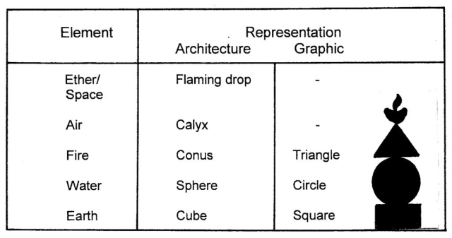
The symbolism of the elements is reflected in the different architectonic parts of the stupa (fig. 140). The lower part of the stupa consists of a square or cube with terraces and steps in various forms. This square/cube symbolized the earth, the most stable and static geometric body. The covering dome is related to the mass of a world all-encircling sea (water). The triangular shape of the conus points to the highest aims, in the same way as flames reach for the sky (fire). The calyx, symbolizing Buddha’s upturned begging bowl, was associated with the sky (air) and the flaming drop is a reference to space (quintessence).
Fig. 140 – The symbols of the (five) elements are reflected in the architectural parts of the stupa and its symbolic rendering is given in geometrical figures. The stupa can be viewed as an architectural representation of the path to enlightenment. It is note-worthy that a quadralectic interpretation of the elements lacks this evolutionary aspect.
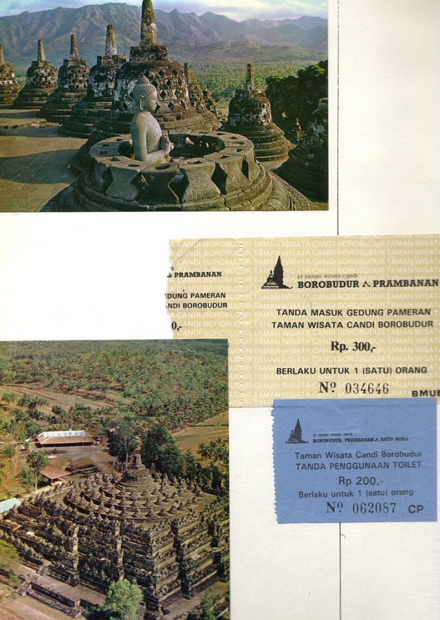
The most famous of all the stupa temples is the Borobudur, forty kilometers northwest of Yogyakarta (Indonesia). The form recalls a stupa, a hemisphere or segment of a globe. Some say that the Candi Borobudur is designed as a mandala rather than a stupa, but both can be true: the former refers to the ground plan as representation of the world (fig. 141), while the latter is the three dimensional symbol of nirwana (fig. 142).
Fig. 141 – The ground plan of the Borobudur Temple on the island of Java, Indonesia. The positions of the hands of Buddha (mudras), which are given in the sculptures of the galleries, have a symbolic meaning. They not only indicate directions, but also the phases of human development. The Bhumisparsha mudra signifies the ‘touching of the earth’ (east). The Varada (Wara) mutra symbolizes charity and compassion (south). The Dhyana mudra points to the principle of wisdom (west). The triangle shape is an identification with the mystic fire and the Three Jewels of Buddhism. The Abhaya mudra means fearlessness, associated with protection and peace (north). It is a sign of good intentions. Finally, the Dharmachakra mudra is related to the ‘Wheel of Dharma’ – pointing to the middle. It sets the teaching of the Buddha in motion.
Buddhism had reached the island of Java in the fourth century, although no architectural remnants of this period are present. The highlights of temple building took place during the Shailandra Dynasty (750 – 850 AD). The Mahayana Buddhism was introduced during this period, but also the more esoteric variety of Vajrayana Buddhism took hold in much the same way as it entered Tibet and Nepal and the Far East during the Indian Pala Dynasty (750 – 1200).
The construction of the Borobudur, the largest Buddhist temple, took place in four different stages. Stage I (775 – 780) comprised the base and two galleries. Two more galleries were added in Stage II (790) added and the foundations were improved. Stage III (810) consisted of dismantling of the round structure, which was built at the end of stage II and three new circular terraces were made. Stage IV (in 820 and 840) consisted of further modification and improvement of the existing structure, with no major changes. The finishing touches were probably made around 900 AD.
The site was then abandoned in the middle of the tenth century, just like the other places of worship in Central Java, when the power base shifted to eastern Java. The Islam religion came to the island of Java in the thirteenth and fourteenth century and the abandoned Borobudur was further covered in volcanic ash and vegetation. Some of the mythical stories about ‘the mountain of a thousand statues’ were recorded in the middle the eighteenth century, in the ‘Babad Mataram’ (History of the Kingdom of Mataram).
Fig. 142 – The Borobudur temple can be interpreted as a large stupa. The five-storied pyramid is subdivided into the three main spheres of Buddhism. 1. The square base (kamadhatu or World of Desire) symbolizes the worldly life. 2. The four terraces above the base represent rupadhatu (World of Forms) with reliefs of Buddha’s life. 3. The following three circular terraces are related to the World of Formlessness (arupadhatu). Seventy-two smaller stupas (above) adorn these latter terraces, reflecting the unity of the whole into the multitude of the parts. 4. An eight-meter high stupa, with a diameter of about fifteen meters, crowns the upper terrace. 5. Finally, a lingam-like spine, symbolizing the calyx and flaming drop, tops the stupa (nirvana).
Visit to the Borobudur. Photo: Marten Kuilman (1992). http://www.flickr.com/photos/57224934@N00/5349559526/in/photolist-99HTEW-ddWC8h-ddWCk9-99EmUh-crr383-crr3b3-crr3eu-crr35U-crr3gY-7TH9AE
It was only when Java became under British rule (1811 – 1816) that the Borobudur caught the attention of the Western world. Sir Thomas Raffles, the English governor of Java, rediscovered the monument in 1814 and paid a visit on May 18th, 1815. Raffles ordered the Dutch engineer H.C. Cornelius to clear the place. The photographic work of Van Kinsbergen (1821 – 1905), during the year 1873, resulted in a series of forty-three photographs, which gave the ruins a further publicity. The hidden base was discovered by J.W. IJzerman, the Chairman of the Archaeological Society in Yogyakarta, in 1885 and a Borobudur display at the Exposition Mondial in Paris in 1900 added greatly to the temple’s fame.
Serious restoration started at the beginning of the twentieth century by Theo van Erp (1874 – 1958), a Dutch army engineer. He replaced missing Buddha heads and panel stones and dismantled and rebuild the upper three circular terraces and stupas. Many sculptures were cleaned of moss and lichen, but he was unable to solve the recurrent drainage problems, which caused sagging of the gallery walls. N.J. KROM (1920/1930) gave a detailed description of the restoration, with many photos of the sculptures of the galleries. The tide of structural instability turned when the Indonesian government and the UNESCO launched the ‘Save Borobudur’ campaign in 1968. The project was completed in 1983 and the temple was put on the UNESCO’s World Heritage list in 1991.
The Shivaistic (Hinduistic) temple-complex of Prambanan is situated some forty kilometers to the east of Borobudur. It matches the beauties of the contemporary Borobudur temple in many respects.
Fig. 143 – A Map of the Prambanan temple complex by N.J. Krom (1920).
Prambanan is Java’s largest Hindu temple complex (fig. 143). The Lara Djong-grang group (also spelled as Lorojonggrang) consists of three large structures and five minor temples surrounded by a wall. The main temple is nearly fifty meters high and is dedicated to Shiva (Ciwa), the Destroyer. The Vishnu (Wisnu) temple is situated at the north of the Shiva temple and the Brahma temple to the south. The complex originally consisted, in Krom’s reconstruction, of two-hundred-and-fifty-six (16 x 16) minor temples, called candi perwara. The middle square was enclosed by a second wall of 220 x 220 meters (modern sources give the figures 110 x 110 meters) The openings in the walls were orientated towards the four wind directions. A possible third boundary wall was located (by Krom), enclosing a terrain of 400 x 400 meters (or more recent 222 x 390 meters) This outer wall also had four openings, but was not parallel to the inner walls.
The (Buddhist) Candi Sewu lies one kilometer north of Prambanan. Its name means ‘Thousand Temples’, because some two hundred-and-fifty minor temples are placed around the central temple. The complex, dating from the first half of the ninth century, was built in the shape of a mandala (fig. 144) and covers an area of 185 x 165 meters.
Fig. 144 – A map of the Candi Sewu (Tjandi Sewoe) complex, near Prambanan (Indonesia) shows the general plan of a mandala. The cruciform main temple is positioned in the middle of an enclosed area and surrounded by the ‘Thousand Temples’, protected by a second wall.
The Candi Sewu has a cruciform ground plan and four stairs in the wind directions (fig. 145). The central part of the building is surrounded by four cellas, one of which leads into the main room (from the east).
Fig. 145 – The main (central) temple of Candi Sewu (Tjandi Sewoe) is an example of a perfect tetradic building, bearing all the symbolism of the one-, two-, three- and fourfold in its architectonic layout.
Many more ‘candi’ (temples) and sanctuaries in Indonesia could be mentioned as representatives of Hindu and/or Buddhist devotion to higher division thinking. The general intention is not exhaustive, but the general conclusion of Indonesian religious architecture has to be one of recognition.
Further study is necessary on the connection of the Hindu religious views and the worship of Buddha on the one side and the modern conception of four-fold thinking on the other side. A search for deep-seated links on a psychological level should rise above the level of numerology. Ways can be explored in the earlier mentioned terrain of non-duality (LOY, 1988; p. 163 and 180). This major characteristic of the philosophical and religious traditions in India and China – and other countries under their sphere of influence, like Indonesia) – might hold the key to an understanding. Both views aim to escape the rigid bonds of oppositionality and point to a world of higher division thinking.
The Buddhist temples of Myanmar (formerly Burma) are another major contribution to the tetradic way of building. Unfortunately, the access to the country was a long time restricted by the government, which wanted to protect its culture from Western influences. Only recently the doors were slightly opened and regulated visits to the country are possible.
More than two thousand temples and pagodas can be found in Bagan, in central Myanmar. Bagan, or Pagan as it was sometimes known, stood as the capital of Myanmar from 1044 to 1287. The golden Shwe-Zigon temple (No 1.) is regarded as the most national of all Myanmar’s pagodas (fig. 146).
Fig. 146 – The Shwe-Zigon temple in Bagan (Myanmar), built in the eleventh century, became the prototype for the later pagodas in the country.
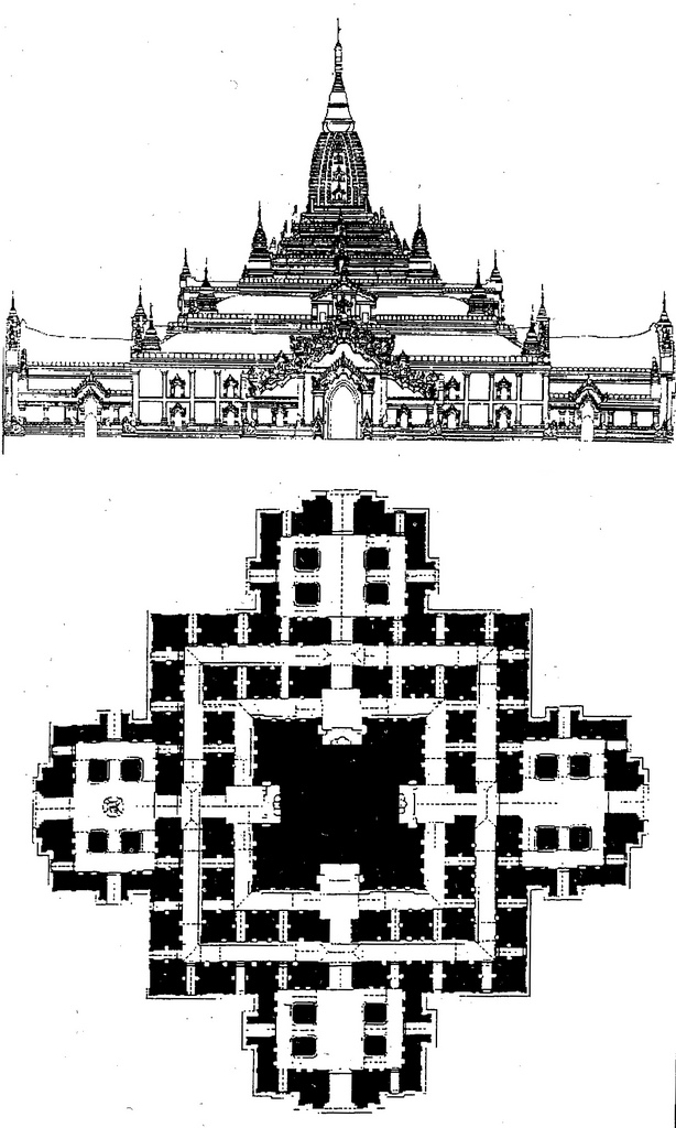
The Ananda temple (no. 2171) also rates high as one of the finest temples in the country. The building activities started in 1091 during the reign of King Nanwrahta (1044 – 1077 and was finished under King Kyanzittha (1084 – 1113). Major restoration and reconstruction took place in 1979. The ground plan is cruciform and the temple square can be entered from all four sides through projecting porches (fig. 147). The central shrine has four large standing Buddha images representing Gautama (west), Kakusandha (north), Konagamana (east) and Kassapa (south).
Fig. 147 – The elevation (above) and ground plan (below) of the Ananda temple in Bagan (Myanmar/Burma). The temple shows different styles and forms of the Early Period, which had come to rest. An enclosing wall and four gateways are integrated in the entire composition.
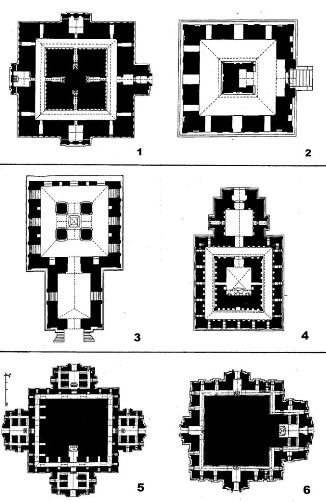
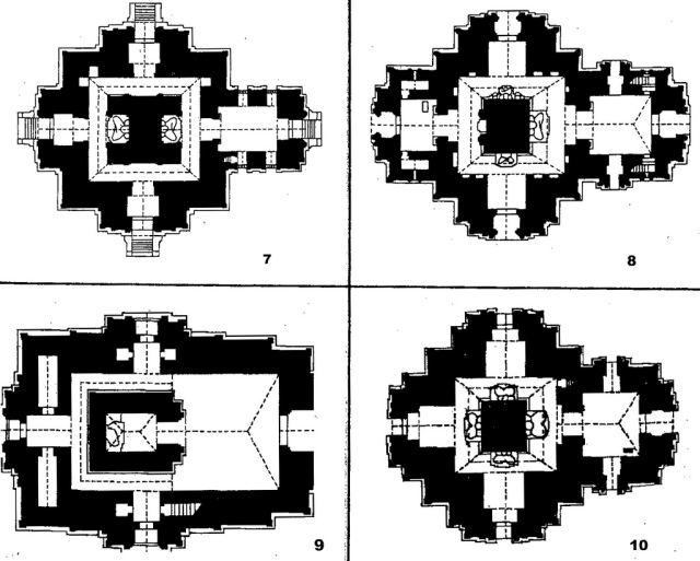
Paul STRACHAN (1989) provided a comprehensive overview of the architecture in Imperial Pagan in Myanmar. The compilation of some ground-plans of temples (fig. 148A/B), do hardly justice to his informative book, but they are a good illustration of the general ‘tetradic’ character of Buddhist architecture in the country. The wide field of temple and pagoda building in Myanmar will be left unexplored at the present time, despite the fact that it represents a major concentration of ‘tetradic’ buildings in the world.
Fig. 148A – The pagodas in Myanmar (Burma) indicate a strong preference to a tetradic way of building. 1. Myin-pya-gu plan forming a lei-myet-hna; 2. Groundplan No.1600 Nat-Hlaug-Kyaung. Shrine confining the Devas. Warly Period, c. 850 – 1120; 3. No. 1239 Nan-hpaya ground plan. Perfect gu temple. Reign of Anawrahta, first free-standing Buddhist ‘cave’ at Pagan. The sikhara is carried by four freestanding piers; 4. No. 1192 Naga-Yon groundplan; 5. Ground plan of No. 771 Dhamma-Yan-Gyi. Grondplan based on the Ananda’s Greek cross type of plan; 6. No. 758 Sulamani ground plan. The Later Period 1170 – 1300. Inner Circle Monuments. Sithu II (1174 – 1211), tireless temple builder. In: STRACHAN (1989).
Fig. 148B – The pagodas in Myanmar (Burma) indicate a strong preference to a tetradic way of building. 7. Plan of Sein-nyet Ama. No. 1085-6 Sein-Nyet Ama (elder sister); 8. Ground plan of No. 1391 Myinkaba Kubyauk-Nge. Late Period; 9. No. 995 Bogyoke-mi groundplan; 10. No. 482 Thambula ground plan. Late Period. In: STRACHAN (1989).
A different story – as far as the number of visitors is concerned – can be told about the famous temple complex of Angkor Wat (Cambodia), which has a high score on the list of the world’s most-favored tourist attractions. The Khmer civilization was almost unknown in the West before the nineteenth century. However, Chinese travelers – in particular Zhou Daguan, who wrote a travelogue on his visit to Cambodia at the end of the thirteenth century – were familiar with the country. The French naturalist and explorer Henri Mouhot (1826 – 1861) is credited to bring Angkor under the attention of the West, when his account was published in English in 1864. Mouhot died three years earlier from malaria in Laos. His tomb was accidentally found near Luang Prabang in 1990, overgrown by the jungle.
The history of Cambodia can be put together by the many inscriptions, in Sanskrit and Khmer, which were found within the area of the Angkorean Empire. Mouhot’s questioning (in his ‘Travels in Siam, Cambodia and Laos’, 1864) that ‘one cannot but ask what has become of this powerful race, so civilized, so enlightened, the authors of these gigantic works?’ is fully justified. The Angkorean period covers the period between 802 – 1327 and listed some twenty-eight kings. Yashovarman I (889 – c. 900) founded the first capital in the Angkor area and made his ‘state’ into the largest and the most influential political power of Southeast Asia. He built his temple-mountain on the hill of Phnom Bakhen, which was considered the geometric center of the town. Under the rule of Rajendravarman (944 – 968) the Baksei Chamkrong, East Mebon and Pre Rup temples (fig. 149) were built, respectively 1.5 kilometers to the north west (Baksei Chamkrong) and six kilometers to the northeast of Angkor Wat.
The early (Pre-Ankorean) temples in Kmer architecture followed the Indian tradition of a temple-mountain until the tenth century. The temple was surrounded by a ditch and had a raised access along the axis of the shrine’s main entrance door. This basic idea was further developed in the eleventh century when a stepped pyramid with a sequence of terraces covered the original hill. This design became more complicated with additions like the gopuras (gateway buildings) and annexes to the shrine (‘libraries’).
The plan of the temple evolved from square to cruciform to central-circular. Two major types can be recognized in the Angkorean period: a centre plan with buildings grouped within the concentric enclosure (like the earlier Pre Rup, fig. 149) and a plan with the buildings arranged along a linear axis (ROVEDA, 1997).
Fig. 149 – The concentric plan of Pre Rup, a small temple which is situated some six kilometers north east of Angkor Wat. The building functioned as King Rajendravarman’s state temple and was built in 961. It consists of two enclosures with gateways at all four sides, a pyramidal structure and five shrines on top.
King Udayadityavarman II (1050 – 1066) was engaged in the building of the colossal temple-mountain of Bapuon, situated three and a half kilometers north of Angkor Wat (fig. 150). The temple was built around 1060 and dedicated to Shiva. The three-stepped pyramid has four enclosures and contains many relief panels, in particular in the gopuras of the second enclosure. The temple is poorly constructed and collapsed several times, but restoration is now in progress.
Fig. 150 – A plan of Bapuon temple, which was built around 1060 by Angkorean King Udayadityavarman II.
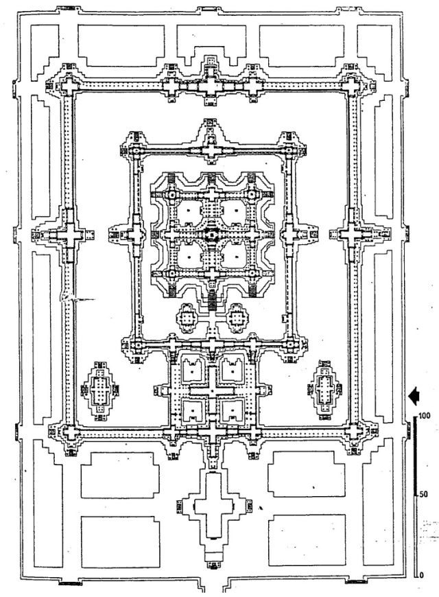
The most important Khmer ruler was probably Suryavarman II (c. 1100 – c. 1150), who built the Angkor Wat temple during the first half of the twelfth century as a mortuary temple (Late Angkorean). The complex was situated in the southeastern quadrant of the old Angkor city of King Suryavarman I. The orientation system is reversed – with the main doors opening towards the west instead of the usual east, which points to a special function as a temple of the underworld.
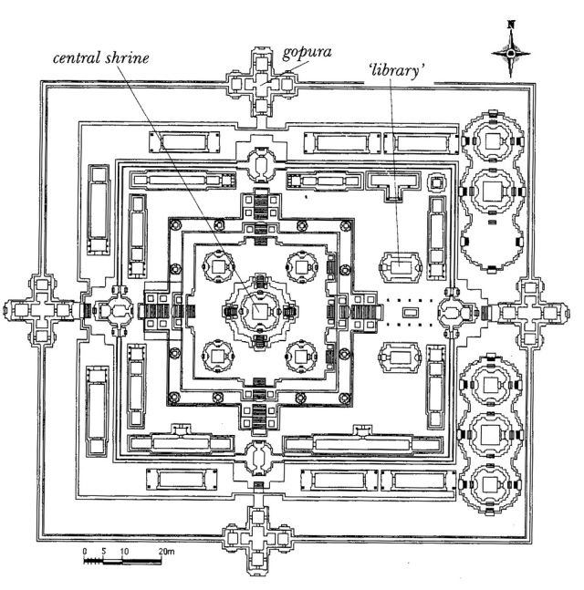
Angkor Wat reached its fame not only by its architectonic outlay (fig. 151), but also by the many sculptures, which adorn the galleries. The panels depict such subjects as the Battle of Kurukshetra (western gallery, south wing) and the Battle of Lanka (western gallery, north wing). The life of King Suryavarman II is given in the reliefs of the southern gallery (west wing). Other subjects are the Heavens and Hells (southern gallery, east wing), the Churning of the Ocean of Milk (eastern gallery, south wing) and the Victory of Vishnu (eastern gallery). Many more scenes can be seen in the corner pavilions, the hall (preau) and the courtyards.
Just to the north of Angkor Wat is the much larger complex of Angkor Thom, which consist of the Royal Palace, (the earlier) Bapuon, a number of smaller shrines and the Bayon on the crossing of the gateways.
The Bayon has a central position in Angkor Thom and was built in the heart of the new capital of King Jayavarman VII (1181 – 1219). The king was devoted to Mahayana Buddhism, although Hindu gods were also venerated. A Buddha was installed in the central sanctuary, but the sculptural reliefs do not make many references to the Buddhist world view. The scenes cover the day-to-day life of the Khmer people and refer to contemporary topics. The central shrine had a circular plan and the entrance faces towards the east. The inner and outer galleries are richly decorated with a continuous frieze of reliefs with soldiers and a military parade (outer eastern gallery), naval battles (southern gallery), but also religious themes and everyday life.
Fig. 151 – The central complex of Angkor Wat, as seen on this map, was constructed in the first half of the twelfth century by Suryavarman II and dedicated to Vishnu.
The eastern religious temple architecture cannot be parted without at least a brief look at China. It is realized that this subject is far too extensive to cover in a limited space. One outstanding example of its rich cultural heritage will be included here to complete this brief survey.
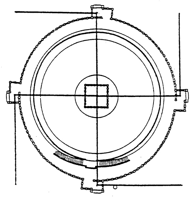
The most sacred of all Chinese structures is the Great Altar of Heaven in Beijing (Peking). The emperor prayed every year in the middle of the first lunar calendar month for a good harvest. The ritual was established in the third century BC. The Circular Hall of Prayer for Good Harvest (Tiantan) was built for this purpose during the Ming Dynasty in 1420 (fig. 152). It became, together with the Forbidden City and the Summer Palace, a symbol of Beijing and a major attraction for tourists. The complex follows tetradic lines, with a reference to time and division thinking.
Fig. 152 – The Great Altar of Heaven in Beijing (China) consists of three circular terraces with marble balustrades (called the Altar for Grain prayers).). There are four staircases to the four cardinal points and four lesser intermediate staircases. The wooden structure – without iron nails, steel rods or cement – is thirty-eight meters high and thirty meters in diameter. The four pillars in the center represent the four seasons of the year, while the inner twelve pillars symbolize the months. The coffer ceiling of the hall is carved with dragons and phoenixes.
The most-rewarding and interesting overview of Asian religious architecture has to be completed here. A preliminary conclusion can be, that the (religious) thoughts, which motivated the architects and builders of temples, shrines and pagodas in the eastern hemisphere – and resulted in such prominent buildings – are not far removed from the basic four-fold ideas. Division and movement are recognized (in the East as well as in the West) as the prime movers of a communication and the elementary appearances find their spiritual translation in the material reality of sacred buildings.
Further research in the religious architecture of Asia from a quadralectic point of view will, most likely, give a conformation of these first findings. The field is still wide open and inviting for any serious scholar.















thank you for sharing very interesting 🙂
Pingback: CHỮ NÒNG NỌC VÒNG TRÒN-QUE: TỪ NÒNG BA VÒNG TRÒN OOO (Phần 2). | Bac Si Nguyen Xuan Quang's Blog
interesting.