
The pyramidal shape of many temples in the Mayan culture might be – just like their Egyptian counterparts – a point in favor of a possible dedication to the four-fold. However, the actual connection between this visible type of geometry and the invisible, historical presence of higher division thinking is, again, difficult to prove. Any attempt to do so, must include the cultural heritage-as-a-whole and should be studied in a nondualistic way. It is only then – in this wider setting – that a possible reward can be found in the messages, which are left behind by those early architects, engineers and craftsman.
Researchers have established the importance of quadripartite symbolism in the religious world of the Indians of the American continent. Anthony AVENI (1988) reached the conclusion that ‘The concept of quadripartition and quadripartite designs was a part of Meso-American cultural insistence, the sum total of artistic, religious, and intellectual endeavor that makes one culture recognisable and distinct from others.’ The four-fold is not always directly visible in the architecture of the temples, but it seemed clear that they were conceived in a tetradic spirit, with a vivid awareness of the multiple character of the visible.
The keyword is space. The understanding of this abstract reality is directly influenced by the type of division, which is chosen as the operating agent of a communication. The creation of form can only be appreciated and valuated in the context of a particular primary division in space. Knowledge of this blending process is of crucial importance in architecture. The Mayas and Aztecs of Mexico and the Incas of Southern America must have been fully aware of this main stipulation of art-in-general. They understood what space was like, and it is no coincidence that their pottery reached such an incredible high standard. Pottery is – like the masterpieces of building – the conscious existence of form in space. Its characterization as pieces of art only comes into being when all four kinds of visibility are brought together in a unity.
The interest in time is another expression of the importance of space in the Mayan culture. There were four basic glyphs to indicate the years: the house (calli), rabbit (tochtli), reed (acatl) and the sacrificial knife (tecpatl). The Maya cosmology was centred, according to ENDRES & SCHIMMEL (1984), on the cardinal points. They were associated with four gods, the Tezcatlipocas and four colours. The black Tezcatlipoca represented the northern aspect, the red Tezcatlipoca symbolised the east, the blue god reigned in the south and the white godhead was in the west. Remarkably, the colors of the gods did not fit the normally accepted compass colors with white in the north, red in the east, yellow in the south and black in the west (NICHOLSON, 1983).
The importance of time in the Mesoamerican cultures might be over-emphasized in the modern, scientific explanations – because ‘time’ is such an imported item in our own cultural experience. The existence of a calendar and a counting system are established, but these arithmetic tools are often viewed from a dualistic point of view. Furthermore, the function and importance of the art of prediction are not always been properly understood. Their setting in a modern scientific approach or in a four-fold, quadralectic position makes a great difference. The handling of time is much more encompassing in the latter philosophical environment. The nature of a linear (dualistic) and a circular (quadralectic) time are one of the more eye-catching operational differences.

Fig. 105 – The Olmec site of la Venta is situated on an island in a tributary of the Rio Tonala (Tabasco, Mexico). The north-south alignment of the conical pyramid with a ten-sided polygonal base (3) and the elongated parallel mounts leads to a quadrangle (5). Late burial mounds are placed on top of the older structures (6).
The pre-Columbian history started as far back as 1500 – 1200 BC with the Olmec civilization. The three main centres of settlement were La Venta, San Lorenzo and Tres Zapotes. The first site (La Venta) yielded gigantic monolithic sculptures of stone heads with ‘negroid’ features.

Villahermosa (Mexico) – Parque-Museo La Venta (Photo: Marten Kuilman, 1988)
Four phases of development were recognized at the Olmec site of La Venta: the first prominence of a ten-sided (mud) pyramid dated from about 1100 BC, the second phase lasted from 1000 – 800 BC, the third and fourth extended from 800 to 400 BC. The complex consisted – besides the mud pyramid – of two elongated parallel mounds with an exact north-south alignment and an empty area in between, which was identified as a ball court (STIERLIN, 1981; fig. 105).
The Olmec civilization must have ended abruptly (either by invaders and/or illnesses) shortly before the beginning of the Christian era. The Maya culture took over its heritage and developed into a formidable civilization of its own, with major centres in Mexico, Guatemala, Honduras, El Salvador and Belize. An overview of the Maya culture and some related people is given in fig. 106:

Fig. 106 – An overview of the social and political evolution of the Mayan civilization and some related centers of power according to HARDOY (1964/1973), WILLEY (1982) and COE (1966/1993).
Many Mayan temples, like the perfect examples in Tikal and Uxmal, were pyramid-shaped edifices. These ceremonial centres were not intended to accommodate large crowds of devotees, but were accessible to priests and dignitaries only. Their prime function was the observation of the sky in an attempt to gain the good will of the gods.
Several attempts have been made to cover the Mayan history in a modern communication graph (CF-graph), but it was found difficult to cover the whole of the Mayan history (as given in fig. 106) in a single, convincing picture. An interpretation of these data in a quadralectic framework implies a search for two ‘visibility boundaries’ in order to construct a CF-graph. This exercise is more difficult to achieve than in many other great cultural periods, like those of the Egyptians, Greeks or Romans. The actual ‘start’ and ‘finish’ of the latter cultures are easier to determine, although still within a certain margin of subjective interpretation.
First of all, the extend of the Mayan’s cultural identity must be determined. Henri STIERLIN (1981) distinguished four main area of their distribution in Middle America:
- A central zone made up of the Petén, including Belize;
- The river valley of Usumacenta to the west (with the cities of Bonampak and Palenque);
- The northern zone covering most of the Yucatan peninsula, containing the Puuc-style towns like Uxmal and Chitzen Itza;
- The southern zone into Guatamala.
The historians regard the city of Teotihuacan, north of Mexico City, as ‘non-Mayan’. The culture of the Teotihuacanos, who controlled the Mexican highlands from the first to the seventh century, is subsequently left out of the Mesoamerican cultural framework. However, in particular in the late fourth century AD, when both cultures reached a peak in prominence, it is hard to imagine that the two centres were complete different entities. Recent scholarship pointed unambiguously to the political and social contacts between the Teotihuacan people in the highlands of central Mexico and the Maya’s in the lowlands.
Geoffrey BRASWELL (2003) edited the contribution of several authors who investigated a range of Maya sites. He demonstrated that the influence of Teotihuacan on the Maya varied in time and place and seemed to be bi-directional. Recently, the discovery of Maya artefacts in the tomb of the Pyramid of the Moon at Teotihuacan added to the growing body of evidence for interaction (POPSON, 2003).
The Teotihuacan-Maya interactions are still a matter of debate. The outcome will affect the inclusion or exclusion of the separate entities in a common cultural identity. It is now acknowledged by STUART (1998), that ‘the Maya consciousness of Teotihuacan changed and developed over the course of four centuries, melding the formidable power and memory of the foreign city with their own political symbolism and ideology’.
The separation of the great architectonic achievements in Mexico into two different cultural blocks is, from a quadralectic point of view, unsatisfactory. There is, undoubtedly, a geographical distance between Teotihuacan in the northern valley of Mexico and the Mayan cities in the jungles of southern Mexico and Guatemala and their temples and pyramids on the Yucatan peninsula. The difference in style of building and pottery is also clear enough for the scholars who studied the material in detail. Nevertheless, the quadralectic consideration aims at a type of general identity, which goes beyond the local, morphological peculiarities.
The whole complex of Mid American cultural visibilities has, in a modern quadralectic view, to be taken into account as a manifestation of creativity in time. Boundaries of visibility should be found in the complete heritage of archaeological remains of the period between the building of Teotihuacan and the final elimination by the Spanish conquerors (initially ignoring the man-made distinction between the various anthropological units).
A proposal for the communication graph is given in fig. 107 as an item for discussion (which holds for all choices of cultural-architectonic boundaries but in particular for the Teotihuacan-Maya cultural complex). The relevant historical data are gathered first and their contribution to the initial choice of visibility indicated. The end result has to be a general view of the cultural achievements of a large number of people living in the Meso American isthmus between the beginning of the Christian era and its disintegration by the Spaniards.
The Olmecs, or ‘people of the land of rubber’, as they were called by the Aztecs, has been left out of the scheme. They might be the remnants of an earlier civilisation-cycle in the same way as the Minoans were supposed to be in relation to the Greek cultural period.

Fig. 107 – This proposal for the communication (CF) graph of the Meso-American cultural period is based on the presence of architecture, pottery and inscriptions (stela) in the Central Highlands of Mexico and the various Mayan areas.
The ‘beginning’ of the (visible) visibility has been proposed at the year 200 BC for reasons, which must be found in another culture, which also cherished its early visibility by pyramids. The Mayan pyramids of the middle of the second century AD are placed at the First Major Approach, just like in the Egyptian cultural period. The end of visibility is positioned in 1500, when the Spaniards effectively destroyed their existence.
No firm marker of the beginning of the Maya culture is available. The boundary of the Early Preclassic (Formative) period is tentatively set by various authors at either 2600 BC, 2500 BC, 2000 BC (rise of the Olmec civilization) or 1800 BC. A choice of any of these data makes a huge difference in the general setting of the CF-graph (and consequently, in the valuation of the Mayan civilization). Therefore, the ‘start’ of the Meso-American cultural period is not useful to construct the CF-graph.
There is a general agreement of the duration of the visible presence of the Teotihuacanos. It runs from 1 – 750 AD, with a peak in the fourth century. Furthermore, the Classical period of the Maya, extending from 250 – 900 AD is well established. The data provide the limits of the most visible period of a culture. The ‘Golden Age’ is situated in the second half of the Third Quadrant. These boundaries are important in the general interpretation of the CF-graph, but they do not provide explicit marker-points.
The presence of the pyramids in Teotihuacan, built in the first half of the second century AD, might be the best point of reference to find the first point of recognition (POR). An analogy with the Egyptian pyramids comes to the rescue here. They were, in the Egyptian cultural period (see fig. 58) a hallmark of the First Major Approach (FMA). This position is characterized by the full depth of creative possibilities. The pyramids in Teotihuacan have that very position in the Meso-American cultural period.
The second point of recognition (POR) is often the Last Visibility (LV). This point – as is known from theoretical considerations (Chapter 7) – is situated at the end of the third part of the Fourth Quadrant (IV, 3). The actual collapse of the Teotihuacan culture in 650 AD and the Mayan culture between 790 and 889 (900 AD, the end of the Late Classic Period) would qualify for such a status. However, by doing so, there is still the period of six hundred years to the Spanish conquerors to account for. Therefore, the Last Visibility (LV) would be better placed around 1500 AD, when the Spaniards ceased the reign of the Aztecs in Mexico.
It is possible to construct the whole CF-graph if two points of recognition (POR) are established. If the first visibility (FV) is placed at 200 BC and the last visibility (LV) at 1500 AD then the results – as given in the CF-graph of fig. 107 – will provide the ‘best fit’ for the Teotihuacan-Mayan cultural complex as a visible entity in world history. The great building activities (Temple of the Sun) in Teotihuacan find their First Major Approach in 140 AD. The year 650 AD, which is crucial in both the history of Teotihuacan (its demise) and the Mayas (their glory), fits into the picture of the Pivotal Point. The Second Visibility Crisis (SVC) – a marker point in any communication as a time of material affluence, but mental alienation and crisis, is designated to the year 820 AD. The Fourth Quadrant – seen in the conventional scientific approach as a time of decline – started in 990 AD, when the importance of the Toltecs and the Aztecs increased. The cities of Chitzen Itza and Tenochtitlan (modern Mexico City) found their greatest glory in this very period.
The CF-graph of the Meso-American culture is not a ‘given fact’ or an indisputable truth, but will remain the subject of discussion. Any progress in the new form of (quadralectic) scientific thinking can only be made in the fair and open reasoning of its foundations, i.e. the nature and importance of the boundaries of visibility. It is well understood, that a redefinition of these boundaries might involve important changes in the character of the communication as a whole. Such modifications, which can vary between minor to very drastic, have to be faced within the quadralectic philosophy.
‘Facts’, like they existed in the ‘old’ (Cartesian) approach of science based on oppositional thinking, are now interpreted as floating entities (or forms of visibilities) in the relation between the observer and the observed. The history of the Mexican culture is a perfect example of this dynamism.
The temple complex of Teotiuacan, also known as the City of the Gods, is situated some fifty kilometers north of the capital Mexico City (fig. 108). Three large temples/pyramids are in close proximity: the Temple of the Sun, the Temple of Quetzalcoatl (or the Plumed Serpent), and – at the end of the Street of the Dead – the Temple of the Moon. The domination and greatest influence of Teotiuacan took place in the early Classic period from 250 – 600 AD (COE, 1966/1993).

Fig. 108 – This general map of the central zone of the city of Teotihuacan, the ‘City of the Gods’, shows a cruciform plan and the locations of the main temples.
The prominent Pyramid of the Sun and the ‘Avenue of the Dead’ in the city of Teotihuacan was built between the beginning of the Christian era and 150 AD. The grid pattern of the extended city took shape between 150 – 300 AD and during the pinnacle of its development in the fifth and sixth century AD, there must have been a population of around 125.000 people. The influence of Teotihuacan over the rest of Meso-America ceased around AD 600, after a curious time gap of fifty years (550 – 600) yielding no historical information. A rapid decline followed around AD 650 and the city met its end around 700 AD through deliberate destruction and burning by unknown invaders.
A section of the population moved eastwards. They founded the Olmeca-Xicallanca dynasty at Cholula (700 – 1292) and became later known as the Putùn-Maya or Chontòl. The pyramid of Cholula reached at one time a height of sixty meters and had a base, which was larger than the Egyptian pyramid of Cheops (fig. 109). The Spanish conquistador Hernando Cortes (1485 – 1547) and his small army, on their way to Tenochtitlan, destroyed the main structure in 1519. The action was part of the intimidation of the Aztecs waiting for him at Tenochtitlan. Later, a Christian church was built on the top of the pyramid (Nuestra Senora de los Remedios). Many more Spanish colonial churches (up to fifty) were built in the surrounding area, showing the determination of the Christian Church to replace the old pagan temples.
Cholula and the nearby city of Puebla remained a center of religious conservatism. The Roman Catholic Church used Cholula as a spearhead in the struggle of controlling the minds of the Mexican people. This interaction of religious beliefs can be interpreted in terms of a confrontation between the ‘pagan’, four-fold way of thinking by the indigenous people and the dualistic, ‘Christian’ mentality of the invaders. This historical approach has never been posed that way. The massacre of 1519 was – seen in that particular light – the anticipated outcome of a peace-orientated tetradic approach of the Mexicans and a power-orientated Christian occupational force under Cortes.

Fig. 109 – The restored part of the pyramid of Tipanipa at Cholula, twelve kilometers north-west of Puebla, Mexico. The place of worship, which appears like a natural hill, is regarded as the large pyramid in volume in the world. The greater part of the structure is still hidden and not excavated.
The Nahua-speaking Toltec had settled in Tula (Hidalgo, central-eastern Mexico) and its ruler had claimed the title of Quetzalcoatl or ‘Featered Serpent’. A further take over of the Yucatan area by the Toltec rulers (after their defeat in Tula in 1156/1168) resulted in the (re) building and adding to such centers like Chitzen Itza and Uxmal. It seemed that the late revival of these cities was inspired by a greater awareness of the four-fold and tetradic architecture in general.

Fig. 110 – A plan of Chichen Itza (Yucatan, Mexico) with the tetradic inspired Castello (or Pyramid of Kukulcan) at a central place in the northern part.
Chichen Itza is one of the most important Mayan archaeological sites on the Yucatan peninsula (fig. 110). The city complex can be divided in three areas: the North, Central and South Group of buildings, roughly coinciding with a progressive increase of age. Some buildings of the Southern Group started around 500 AD, when the first known settlement in the area took place. They are known as Old Chichen and consist of at least ten temples, which such names as the Temple of the Hieroglyphic Door Jambs, Temple of the Phalluses, Temple of the Little Heads, Temple of the Owls, Temple of the Four Lintels, etc. There are also the ruins of the Old Castillo.
The Central Group dates from the early Classical period (600 – 900 AD) and the Transitional Period (900 – 1000 AD) and comprises of, among a number of other structures, the Ossuary, the House of the Deer and the Caracol or Observatory. A spiral staircase led in the latter building to an observation chamber (see also fig. 772).
The Northern Group of buildings dated from the youngest Maya-Toltec period (1000 – 1250 AD). The famous El Castillo (the Castle) or Pyramid of Kukucán is part of this latter development (fig. 111). A remarkable effect of light can be seen during the spring equinox on the west ramp of the main staircase. When the sun reaches the steps in the afternoon seven triangles of light and shade appear, forming the body of a serpent.

Fig. 111 – A plan of El Castillo or the Pyramid of Kukulcan in the northern part of the Chichen Itza temple complex (Mexico). The structure was built during the Maya-Toltec period (1000 – 1250 AD) on top of a similar, but smaller temple.
The Temple of the Warriors (Templo de los Guerreros) is also part of the Northern Group and is adjoined by the Plaza of the Thousand Columns, which was built between 900 and 1200 AD. The Grupo de las Mil Columnas is characterized by its multiplicity and seem to point to a ‘Fourth Quadrant’ approach in architecture.
The circular El Caracol (or the Observatory) is an enigmatic building in the complex (fig. 112). The structure is part of the Central Group and is situated near the Xtoloc Cenote (well) (see fig. 110). Its form and function might point to the importance of the universe as a reference in a communication. The observations took place in a circular building with various windows to divide the field of view (the universe) in distinct parts. The shifting pattern of stars within these division-areas could have provided certain information about events. The key to this type of ‘universal’ belief is the analogy with a tetradic outlook in the mind of the observer.

Fig. 112 – A drawing of the elevation and plan of El Caracol or the Observatory at the Chichen Itza complex in Yucatan (Mexico) is given here. The observatory is twenty-two-and-a-half meters high of which the – later added – circular tower measures about thirteen meters. The plan on the right hand corner shows the four major observational directions: 1. The Meridian pointing to the south; 2. The summer moon at –29 degrees; 3. The Equinox sunset at 0 degrees and 4. The winter moon at +29 degrees. The Caracol was heavily damaged, in particular the northeastern section, but is now restored to its original glory. It is possible that there were other windows in the northeastern section.
Furthermore, in Yucatan (Mexico), about fifteen kilometers north of the city of Merida is another significant Mayan temple, known as the House of the Seven Dolls (Templo de las Siete Muñecas) in the ancient city of Dzibilchaltun (‘Place where there is writing on the stones’). The temple was named for the seven small sculptures excavated here and now placed in a museum in Mexico City. About eight thousand ruins are mapped in the area with the major focal points linked by causeways. A deep cenote (well), called X’lakah (meaning ‘Old Town’ or ‘Old People’), is part of the complex. It has a depth of over forty meters and ends in a horizontal tunnel. Many stone artifacts have been found at the bottom of the well.
The Temple of the Seven Dolls has a square base with a central chamber encircled by a corridor (fig. 113). The square building has a tower instead of a roof comb and is, for that reason, also known as the Observatory. Steps lead up to the building on all four sites. It is aligned with major astronomical points and has windows. Every year during the spring and autumnal equinox the sun shines directly through the doorway as it rises. Other openings in the building are positioned for the summer and winter solstices.
A stele, forming a perfect tetradic monument with four staircases re-presenting the corners of the earth, is situated in one of the causeways. The sun passes through the ‘House of the Seven Dolls’ at the vernal and autumnal equinoxes and aligns with the upright stone of the stele (fig. 114).

Fig. 113 – The Temple (House) of the Seven Dolls at Dzibilchaltun (Yucatan, Mexico) is a Mayan temple/observatory executed in a perfect tetradic style.

Fig. 114 – The stela is in alignment with the Temple of the Seven Dolls (in the background) at Dzibilchaltun (Yucatan, Mexico) when the sun passes through the ‘Temple of the House of the Seven Dolls’ at the vernal and autumnal equinoxes.
The ancient city of Uxmal – meaning ‘thrice built’ or ‘thrice occupied’ in the Mayan language – is situated some hundred-and-ten kilometers south of Merida (Yucatan). The place was first visited by the American explorers Stephens and Catherwood in 1839.
The former (John Stephens; 1805 – 1852) wrote in his successful travelogue (‘Incidents of Travel in Central America’ (1843): ‘We came at once upon a large open field strewed with mounds of ruins, and vast buildings on terraces, and pyramidal structures, grand and good preservation, richly ornamented, without a bush to obstruct the view, and in picturesque effect almost equal to the ruins of Thebes..’. Frederick Catherwood (1799 – 1854) illustrated the book with hundred-and-twenty accurate engravings. Stephens and Catherwood knew what they were talking about, because they had been in Egypt on different occasions and had visited the pyramids and the temples of Karnak.
Uxmal was one of the largest Mayan cities of the Yucatan peninsula and flourished in the Late Classical period (from around 600 – 900 AD). The Nunnery Quadrangle and the nearby temple, called the House of the Magician, have distinct tetradic features in setting and decorations (fig. 115). The name of the Nunnery (Casa de las Monjas) was given by the Spaniards because of the similarity to the convents in their homeland. Each of the four buildings has ornate facades. The building might have been used as a school for the training of astronomers and priests and/or housed visiting dignitaries or administrative offices.
The Pyramid of the Magician might be more aptly named in reference to its former function. The structure is, with its height of thirty-eight meters the tallest structure in Uxmal. It consists of five superimposed temples and must have been the highlight of the ceremonial center.

Fig. 115 – A part of the wall of the Nunnery Quadrangle at Uxmal (Yucatan) with a tetradic-like design reflected in the crossed masonry within the expressive structures of the building.
The Mayan archaeological site of Palenque is situated on either side of the Otolum River (in the state of Chiapas, Mexico). It is also regarded as an important ceremonial center with temples and a palace (fig. 116). Its prominent geographical position could have contributed to the Spanish name of Palenque, meaning ‘fortification’. However, the Spaniards might also have taken the translation of the Mayan name – Otolum meaning ‘Land with strong houses’ – into account.
Palenque’s visibility started, according to the hieroglyphic texts, in AD 431, but its main phase of architectural development took place in the seventh century and lasted until about 810. Thereafter the Maya civilization lost its strength and the cities were gradually abandoned. Palenque was one of the first cities to be given up and given back to nature. The seven-hundred- years-old ruins were mentioned by Father Pedro Lorenzo de la Nada in 1567, but then a period of two centuries followed in which European and/or American explorers did not pay any attention to this part of the world (at least not in a written form).
This attitude changed towards the end of the Third and beginning of the Fourth Quadrant (of the European cultural history, around 1800), when the number of expeditions and publications increased. The book ‘Descriptions of the Ruins of an Ancient City, discovered near Palenque’ was published in London in 1822. It seemed that the interest in the Mayan world and its cultural heritage only came to live when the intellectual climate in the Western world was ready to grasp the width of their frame of mind.
In hindsight, it can be said that the three great periods of ‘discoveries’ in the Western cultural history took place at the beginning (1200), middle (1500) and end (1800) of the Third Quadrant. These positions are related to a changing pattern in the way of division thinking, either by narrowing down to the three- and two-fold (1200), or bringing oppositional thinking to its ultimate boundaries (1500) or, finally, by opening up its restrictions into the field of wider, tetradic thinking (1800).
The Mayan culture, and in particular their ceremonial centers like Palenque, should be seen in the light of a wider point of view. Maybe, their intellectual avant-garde, like the mathematicians, shamans or priests, already knew the depth of tetradic thinking. It is possible that astronomical observations and ceremonies found their very inspiration in the exploration of the width of higher division thinking. To study these questions – and give convincing answers – would imply a complete new approach to the Mayan history.

Fig. 116 – A plan of the eastern section of the Mayan archaeological site at Palenque (Chiapas) by Henri Stierlin (1981). The Palace and the Temple of the Inscriptions are the most prominent buildings in the central area. The latter temple contained a stone chamber with an elaborately carved sarcophagus, belonging to Pacal the Great, who ruled from 615 to 683.
The first lowland Maya stela at Tikal (Guatemala) was dated at 250 AD, but the city of Tikal reached its greatest prominence around 500 AD in the Classical Period of the Mayan culture (fig. 117). The position of Tikal within the greater Meso-American context is still a matter of debate, in particular in relation to the city of Teotihuacan, which reached its importance at about the same time.

Fig. 117 – The plan of the central part of Tikal by Michael COE (1966/1993). The numbers 1 – 5 point to the Temples I – V; The Temple of Inscriptions (6) is about 1.2 kilometers to the south east along the Calzada Mendes; 7. Great Plaza; 8 – 14 Reservoirs. The Mundo Perdido (Lost World) complex is situated to the west of Temple V (57 meters) and the South Acropolis. The westernmost Temple IV, with its 65 meters one of the tallest pre-Columbian structures in the Western Hemisphere, provides a spectacular panorama.

Plan of Tikal – Local leaflet (1988).
Maria Josefa Iglesias Ponce de Leon stated (in: BRASWELL, 2003; Chapter 6) ‘that an undue emphasis on the presence in the Maya area of certain central Mexican goods has resulted in interaction models that exaggerate the importance of Teotihuacan to the development of Classic Maya complexity’.
Archeologists in the 1960s and 1970s saw the presence of an architectural feature called the talud-tablero and the occurrence of cylindrical tripod vessels and green obsidian as an influence of Teotihuacan on the city of Tikal, but this opinion has since been questioned. Abundant material from ‘problematic deposits’ at Tikal (in particular PNT-21, consisting of more than 167.000 sherds) indicated further negative evidence for a direct cultural exchange and pointed to a local Maya tradition.
The present, architectural attention to Tikal will focus on the ‘tetradic’ aspects of its buildings. Probably, the most important feature is the pyramidal structure, which was widely used in Mayan architecture. This shape grew naturally from a mound, which was enlarged in the process and staircases were added. A ground square with a sloping wall (talud) formed the base of a flat table on the top (tablero), protruding slightly from the lower section. The vertical tableros could also be framed and were often painted (fig. 118).

Fig. 118 – This sketch indicates the talud-tablero structure, which is typical for the Meso-American (Mayan) architecture. Many variations on this theme can be found in Teotihuacan (The City of the Gods), Tula, Cholula, Monte Alban, Mitla, Tikal and other sites.
The pyramidal shape in general represents the sacred mountain, and the originally buildings might have been covered in a rich color pattern. The ‘Temple of the Great Jaguar’ (Temple I) at Tikal was the burial site of the ruler Ah Cacao, or King Chocolate, who was laid to rest around 700 AD. The pyramid is – with its 45 meters – not the tallest hallmark at Tikal, but it is certainly the most impressive one (fig. 119).

Fig. 119 – A view of Temple I or the ‘Temple of the Great Jaguar’ at Tikal. The building is a conspicuous example of tetradic architecture within the Mayan cultural history.
Opposite to the west of the ‘Temple of the Great Jaguar’ is Temple II – or the ‘Temple of the Masks’ – which was built by the same ruler. Temple III is still partly covered in jungle vegetation and reaches a height of 55 meters. The westernmost Temple IV, also called the ‘Temple of the Two Headed Snake’, was built by King Yaxkin Caan Chac around 470 AD. The entrance to his tomb is at the halfway terrace. It reaches to a height of 65 meters and is the tallest building at Tikal and probably of the whole Western Hemisphere at that time. Temple V was recently restored and is situated at the south of the Central Acropolis. The Temple of the Inscriptions is somewhat further away, southeast of Group G. It was completed around 750 AD.
Another striking example of tetradic architecture can be found in the Great Pyramid (Str. 5C-54), which is the principal building at the Mundo Perdido complex (fig. 120). A number of construction episodes of this building cover a period of one thousand years (Juan Pedro Laporte in: BRASWELL, 2003; Chapter 7), but came to prominence in the fifth construction period during the Terminal Preclassic, i.e. in the third century AD. The building of the nearby pyramidal structure (Str. 5C-49), one of the most important temples of Mundo Perdido, must have started at that same time, with a second version in the fourth century (Manik 2). The talud-tablero form, which was used here, continued to be used in the fifth century (Manik 3).

Fig. 120 – An overview of the Mundo Perdido complex in Tikal as it looked between AD 700 – 800, just before its demise a century later. The Great Pyramid (Str. 5C-54) is situated to the right and the smaller one with the temple (Str. 5C-49) to the left.
The Pyramid of the Lost World (fig. 121) is interpreted as an astronomical viewing platform. The pyramid had four stairs, one to each side. The observers used these stairs as a level for the three temples to its east and the position of the rising sun at the midsummer solstice (north building), the equinoxes (center building), and the midwinter solstice (south building).

Fig. 121 – The Great Pyramid (Str. 5C-54) of the Mundo Perdido complex in Tikal represents a firm tetradic statement, which influenced the further development of the city. The present pyramid, with a ground square of 80 x 80 meters and a height of 32 meters covers several smaller versions dating back to 700 BC. The first tableros appeared in the fifth construction episode around the third century AD.
Uaxactun, some forty kilometers north of Tikal (HAWKINS, 1973; p. 182) has a similar setting. The site was built around the year 300 AD. The earliest dated inscription (328 AD) was found on Stela 9. The most recent inscription was engraved on Stela 12 in 889 AD. However, its earliest history might go back to 900 BC, thus making it one of the longest Mayan cities in existence. Three roofed temples to the eastern side of the pyramid provide the markers for the settings of the sun at the spring and fall equinoxes (Middle temple), Midsummer’s Day (Northern Temple) and the midwinter solstice.
The modern, quadralectic interpretation of these findings does not intend to diminish the importance of the reported facts, but would put the emphasis on the dynamic character of the observations itself – rather than on the establishment of four specific positions of the sun throughout the year. It could well be, that the relation of the observer and external marker points (either in- or excluding the sun) and certain ‘rules’ to measure that relationship, were more important to the Mayans than any particular cosmic event in time.
Many Western (pseudo) scientists tried to prove the importance of time in the Meso-American cultures in much the same way as they attempted to ‘explain’ European megalithic features (like Stonehenge). The study of the Dresden Codex – as the major source of Mayan astronomy – has been an achievement in its own right, but it indirectly hailed the perceptive time-consciousness of the Mayans. Few investigators paid attention to the act of observation itself – and the notion of place therein. The interaction between observer and location depends for a great deal on the type of division-environment. Maybe the Mayas realized that the multiple (four-fold) way of thinking could hold a key to a new experience of their position in a (cyclic) cosmic presence.
Peter D. HARRISON (1999) pointed in his book ‘The Lords of Tikal’ to the ancient history of the Mundo Perdidio Complex, with the emphasis on war (’Star Wars’) and battles. His approach is typical for the way archaeology can respond to popular demand. The so-called Hiatus, for instance, was a period of hundred-and-twenty-five years (AD 557 – AD 682) with little recorded history available ‘largely due to warfare between Tikal and its neighbours’. It marked, according to Harrison, the beginning of the Mayan ‘star wars’ or battles timed to astronomical events. He concluded that ‘the absence of surviving monuments and texts is assumed to be the result of domination or the intense conflict of the period’.
This conclusion must be amended from a quadralectic point of view. It is a given fact that most cultural entities are punctuated by struggles, wars and battles, which are typical for inter-human relationships. However, these times of heightened activity nearly always leave traces if not to say scars. War, by its very nature, is an expression of oppositional thinking and duality, resulting in material visibility: burned villages, dead people, destruction, but also a search for resources, inventions and new life. In fact, most history of the classical type is written along lines of wars and conflicts. These events seemed to be the stuff that really mattered in the confinement of lower division thinking.
The absence of recorded history does, in a classical approach, hardly point to people at war or under foreign occupation. A different solution is proposed here and is worth further study: people living during the Hiatus were totally at peace with their own personality, their government and their neighbours. There was no need to record a state of almost complete material and spiritual well-being. Life is taken as it is, in a state known by the philosophical Taoists as wei-wu-wei. This notion can be translated as ‘the action of nonaction’ or ‘act without doing’ (Stephen Mitchell). The paradox – as mentioned in the opening words of Chapter 63 of the Tao Te Ching – is central in Taoism and only second in importance to the Tao itself (David LOY, 1988; p. 97).
The Mayans might have found this state of mind in their tetradic thinking, occupying themselves with the meaning of life on a supra-material level. They did not leave visible traces for the fact-hungry archaeologists of the nineteenth and twentieth century. The ‘collapse’ of the southern Mayan area at the end of the nine-century AD, including such cities as Palenque, Tikal and Copan could be explained in the same way. Researchers looked for great acts of nature, disease, soil exhaustion or any sort of internal trouble, but could not come up with a convincing argument. Maybe the reason of the ‘decline’ was the absorption of the people with matters that did not translate into visible visibility.
This fading-away is not as heroic as a gigantic battle or an act of nature of the Pompeii-type, but cannot be excluded. The waning visibility of the southern cities within the context of a (quadralectic) communication is worth a closer look, assuming that the CF-graph of the Meso American cultural period (fig. 107) holds some truth.
The Hiatus (557 – 682) is situated at the Pivotal Point (650 AD). This point (PP) is often regarded – in lower division thinking – as a ‘midlife crisis’, where the oppositional character of a communication becomes (painfully) aware. The extreme ideas and facts of the past, present and future ‘fight’ for supremacy and existential questions can be asked. The four-fold mind reacts different. The Pivotal Point (PP), in the middle of the visibility period (X), loses its specific character as the whole of the communication cycle (V) is taken into account. The position within this wider context (10/16 or 5/8.V) is of no particular significance.
The ‘end’ of southern lowland cities towards the year 900 AD can be situated (in fig. 107) towards the middle of the fourth part of the Third Quadrant (of the Meso American cultural period). This stretch of time is in most communications an apogee of visibility, but also a time of distinct changes pursuant to an increased awareness. The approaching width of thinking (of the Fourth Quadrant) casts its shadow before. The southern cities might have opted out for further prominence. A modern approach to history suggests that this choice be made in a fully voluntary way, leaving the struggle for survival and visibility to the more northern representatives of their civilization.
The archeological site of Kaminaljuya, in the outskirts of present-day Guatemala City (Guatemala) provided an important link with other Mayan cities and architectural styles. The site probably dates back to the early Preclassic period (800 – 300 BC), but was then abandoned. Some centuries later the city grew in importance and contained over hundred platforms and mounds at approximately 150 AD. Further development reached a climax during the Early Classic (300 – 600 AD) at about the same time as Teotihuacan and Tikal.
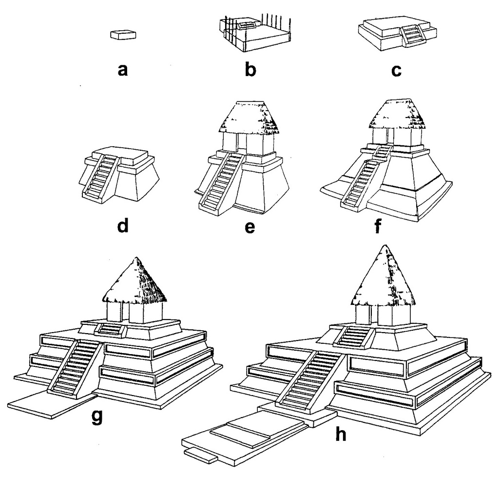
Fig. 122 – The construction sequence of a mound at Kaminaljuyu (Guatemala), as studied by Alfred Kidder in the late fifties of the previous century (Mound A), gives the various phases in the building process (in: BRASWELL, 2003).
The letters a – c represent the early stages, when simple shrines or altars, made of earth were erected over burials (early Esperanza phase, 400 AD). The letters d – f indicate the structures A-4 to A-6 consisting of a single, large talud, but also contained a vertical cornice and stairs with balustrades. Certain elements of the talud-tablero style were already present (Integration phase). The letters g and h point to the stage A-7 and A-8 and mark the presence of the talud-tablero style (Teotihuacan phase, around 500 AD). Building in that style continued on the nearby Acropolis (north of Lake Miraflores) for at least another hundred years, up to AD 610.
The matter of correlation between the major Mayan centers and the ‘influence’ of the Teotihuacan ‘style’ to archaeological sites like Kaminaljuyu and Tikal is still a matter of scientific debate.
The Aztecs provided the final visibility of the Meso American cultural period. They originated – according to their own legends – from the city of Aztlan, presumably situated in northwestern part of Mexico. The name Aztecs was only coined in the nineteenth century. The most powerful ethnic group encountered by Hernan Cortez (1485 – 1547) was the Mexica, leaders of the Triple Alliance.
These people (Mexica/Aztecs) settled in the central part of Mexico in the thirteenth century and set up their main base on an island in Lake Texcoco. The town of Tenochtitlan was built from 1325 onwards. Their influence developed rapidly in the fourteenth century and the Aztecs’ civilization was in a mature state when Cortez entered the country in 1519.
The knowledge of the culture and customs of the Aztecs is fairly good. The contacts with European conquerors were followed by descriptions, which reached Europe in a critical time of its own cultural development. Europe had advanced to the Pivotal Point (PP – 1500 AD; see fig. 267, p. 332), which is a marker point for the extremes in oppositional thinking. This setting of bringing opposites to their ultimate psychological consequences had brought the Spaniards to America in the first place. It had also given them gunpowder and exotic weaponry – like their sixteen horses, which were unknown to the Aztecs.
The Aztecs, on the other hand, under their ruler Montezuma, lived in a ‘Fourth Quadrant’ setting. They had acquired earthly riches (gold) in the past two hundred years and enjoyed the blessings of a smooth social organization, based on a mutual belief in a sacred power. The importance of prediction and foreboding – which is an essential element of higher division thinking – has always been highlighted in the story of the Aztecs. When Montezuma heard the news that ‘the gods have come back and that their warriors have two heads and six legs, and they live in houses that float’, he knew that history was about to fulfil itself. The ‘Plumed Serpent’ was returning to his people.
Apparently, some ideas about cyclicly took a firm degree of reality at the time (NICHOLSON, 1983; pp. 95 – 97: Four Aspects of Nature). This state of mind occurs at two distinct positions in a (quadralectic) communication. The first occurrence is around the Pivotal Point (PP; mid-Third Quadrant), as a consequence of radical duality. A stringent application of dualistic thinking into a wider intellectual context often results in a ‘crypto-tetradic’ mood, which is akin to the manifestation of numerology.
A second prominence of a recurrent type of history is noticeable in the final stages of visible visibility in a communication. The phenomenon of cyclicly itself is brought to its consequences in the last part of the Fourth Quadrant. Past, present and future become a unity. The result of this insight leads to a sense of cosmic understanding, in which everything passes by in an eternal cycle movement.
The Aztecs and their historic legacy bear all the characteristics of a ‘Late Renaissance’, in the same way as it took place in the Egyptian cultural period. The artistic achievements of the Saite Dynasty (XXVI Dyn.; 664 – 525 BC) gave the recapitulation of Egypt’s glorious past in the Old and New Kingdom. See p. 87, fig. 58 for the position of the Late Renaissance on the CF-graph and also the remarks on p. 105 regarding the foundation of the dynasty in Saïs.
Some believe that the true character of a cultural presence lies in its physical presence during its heydays or Golden Age. They use the word ‘decadence’ for the last glimmerings of a culture visibility. However, this characterization has to be rejected within the quadralectic context. The last bits of visible creativity are often inspired by the highlights of the past, and come to life in their own unique, eclectic nature.
The numbers 4, 5, 7, 9, 13 and 20 were important references in the mythological and numerological life of the pre-Columbian people of Central America (RAYNAUD, 1901). The numbers 4, 7, 9 and 13 were considered to be sacred numbers. The relation of these key-figures to the numbers 1 and 4 is significant:
The vigesimal numeration (based on 4 x 5 = 20) is a sign of a highly developed sense of mathematics. There were four symbols used: a dot, circle or finger (1), a hatchet or flag (20), a feather (400) and a symbol looking like a string purse or bag of incense (8000).
The first writings about the Mayan number system date back to the fourth century AD. The present knowledge of the Aztec numeration system is mainly derived from Spanish translations, notably the Codex Mendosa (Bodleian Library, Oxford University). The Mayan and Aztec mastering of mathematics might have found its origin in the deeper understanding of cyclicity, situated in a mental environment of higher division thinking, in particular the four-fold way of thinking.
The architectural achievements of the Aztecs are an apotheosis of the long record of building throughout the ages in the Mid-American realm. Their authentic comprehension included a more than average interest in higher-division thinking (the four and five-fold), which is reflected in their architecture. In particular the outlay of the capital Tenochtitlan and the sacrificial temple (Templo Mayor), which was used as a place to sacrifice people to the gods, reflected the complex world of tetradic thinking.
The main division framework was formed by four cosmic suns or world periods, symbolized by the jaguar, the wind, the rain and the water (SELER, 1906; NOWOTNY, 1976). Tezcatlipoca, the god of night and sorcery, also known as Smoking Mirror was the most powerful, supreme deity, which was associated with the notion of destiny.
The offspring of the one god-above-all were the four Tezcatlipocas, which were typified by different colours. The black colour represented the northern aspect, red the eastern, blue the southern and white the western direction. These four Tezcatlipocas (of the first division) were standing at the corners of creation and were revolving round a centre ruled by the god Tepeyollotl, the Heart of the Mountain, one of the Lords of the Night (fig. 123).

Fig. 123 – A representation of the division of time and place is given here as a reflection of the psychological context of the Aztecs. Left: the ritual calendar Tonalpohualli, divided in 13 x 20 (260) days, every day with its own name. Right: the five parts of the world according to the Aztecs and given in the Codex Fejérváry-Mayer. In the middle is the fire god Tepeyollotl, surrounded by the four Tezcatlipocas. The map is orientated with the east pointing upwards.
The four Tezcatlipocas had a parallel in the (older) Mayan belief in the four Bacabs, belonging to the points of the compass. The Bacabs were canopic gods, thought to be brothers, supporting the sky. They might also be four manifestations of a single deity. Each Bacab presided over one year of a four-year cycle. It seems that the boundary between the unity of the universe (sky) and the primary division (wind directions) is explored in these gods in the same way as the boundary between the First and the Second Quadrant is known to be of the utmost importance within the quadralectic worldview.
The red Tezcatlipoca belonged to the east and was associated with sunrise. The deity became known as Xipe Totec (god of spring) or some-times Tonatiuh, the Sun itself. Tonatiuh (the sun) was seen as the primary source of life. Its east-west path determined the principal ritual axis in the design of Aztec cities. The four year-signs are basic time units and also point to a further association with the four-division: Calli (house), Tochin (rabbit), Acatl (reed), and Tecpatl (flint knife). A position in the Second Quadrant is proposed here.
The blue Tezcatlipoca of the south became the god Tlaloc. Tlaloc (‘He who Makes Thing Grow’) is the rain deity with his temple at Mount Tlaloc. An important shrine was located in the Templo Mayor of Tenochtitlan. The worship of Tlaloc concentrated on fertility, but also included the sacrifice of humans to appease the gods. These human thoughts about the extremes of nature (like floods and droughts) – or creation and destruction in general – point to an attention to ultimate boundaries, which is typical for the op-positional setting of the Third Quadrant.
The white Texcatpolica was embodied in Quetzalcoatl, who was associated with the sunset in the west. The god Quatzalcoatl became in the religious awareness the great mediator in the continuous struggle between the three other Tezcatlipocas. He was involved in the cycle of the Four Suns, a succession of eras with their own distinct life forms (quadrants?). The mythical history told the story of the Aztecs, which passed the end of the Fourth Sun and Quetzalcoatl was forced to leave the country. Nobody knew when he came back, but his return was eagerly awaited. An analogy with a position in the Fourth Quadrant (or more precise in the fourth part of the Fourth Quadrant) seems appropriate here.
The Templo Mayor (Huey Teocalli) of Tenochtitlan is situated at the zocala (or central square) of present-day Mexico City (fig. 124). The building was orientated towards the four quarters of the universe and consisted of a pyramidal platform (80 x 100 meters) with four sloped tiers with a passage between each level. The central point was between the thirteen levels to heaven and the nine steps to the underworld. Two stairways gave access to two temples with shrines or chapels dedicated to Tlaloc, the rain (water) god and to Huitzilopochtli, the god of war. The temples must have been about thirty meters in height, decorated and covered with stucco and polychrome paint.

Fig. 124 – A plan of the Templo Mayor of Tenochtitlan and its relation to the present layout of Mexico City center demonstrates the quadratic division of space. The block shape (fine dotted lines) of modern Mexico City is superimposed on the older temple design. The city of Tenochtitlan and in particular the double pyramid of the Templo Major epitomize the tetradic spirit, which must have been the mainspring of the cultural existence of the Aztecs.
The Inca Empire in Southern America is a very different story in comparison to the long history of the Mayans, Toltecs and Aztecs in Central America. However, their joint Indian roots resulted in certain similarities in their way of thinking, which can be reconstructed from their cultural heritage.
The actual Inca history lasted only some hundred years, although earlier cultures, like the Killki (700 – 800 AD) and the Lucre culture (around 1000 AD) had been their predecessors. Maybe these prior cultural presences have to be included in an overall picture of the South American civilization, but no such lines are being followed now. The Inca legend credited Manco Capac and his sister Mama Occio as the founder of Cuzco (Peru) around 1200 AD. It was only under their ruler Pachacuti (in 1438) that the Incas became true empire-builders. When the Spanish conquistador Pizarro (1474 – 1541) reached Cuzco on November 15, 1533 it was all over.
The Inca Empire was also called Tawantisuyu, meaning the Land of the Four Corners. In its heydays, it covered some four thousand kilometers along the Pacific Ocean of what is now southern Columbia, Ecuador, Peru, Bolivia, north west Argentina and Chile. Its origin was in the early part of the thirteenth century AD in Cuzco and from here it extended between 1430 and 1524 AD to its greatest influence over about six million people.
The Tawantisuyu was divided into four quarters, or suyu, with Cuzco in the centre. The following division was made:
Direction Name Area
— E Anti suyu Land of the Amazonian forests
— SE/S Colla suyu Colla tribe near Lake Titicaca
— SW Cunti suyu Land of the setting sun
— NW Chincha suyu Most prosperous suyu
The empire, as a political-imperialistic movement, tried to impose the cult of the Sun throughout the world. They gained a superior technical knowledge and consolidated an efficient administration in the conquered territories.
Machu Picchu is probably the most famous city of the Incas. It is situated at the Urubamba River valley in the Cordillera Vilcacamba in south-eastern Peru. It was occupied during the Inca Period and abandoned after its disintegration, probably after 1572. The ruins of the city were discovered more than three hundred years later by the American explorer Hiram Bingham (1875 – 1956) in 1911.
The city stands on a promontory and is surrounded by deep canons. Jorge HARDOY (1964/1973; p. 483) noted that the city ‘is not a good example of the Inca Empire’s characteristic pattern of human concentration, that is, the planned city, the administrative centre, or the agricultural village’.
In Bingham’s own description of the approaches to the ruins (in: BINGHAM, 1948/1979; p. 142) he described another Inca village, with the name of Palcay. Here was a ruined stronghold, named Llacta (meaning ‘town’) sur-rounding a quadrangular group of houses:
‘The chateau, if so it might be called, was about 145 feet square and divided by two narrow cross streets into four equal quarters. Two of these quarters had been completed, and consisted of five houses arranged around a courtyard in a symmetrical fashion. The third quarter was almost complete, while the fourth quarter had only the beginning of two or three houses. Each one of the four quarters had a single entrance gate on its north side. The gnats were very bad, which made the work of measuring and mapping the ruins extremely annoying’.
The most remarkable feature of this Inca stronghold is that the streets run north and south, east and west, on the exact cardinal points. These ruins are in the Southern Hemisphere, so the North Star is not visible, yet one street follows the meridian exactly. How was it done?’
Machu Picchu lacked an overall plan and its development was based on the natural restrictions of the topography. Any reference to a four-fold layout is missing. There is a prominence of stairways in the city and the most typical architectural feature is the sundial stone, or intihuatana, (fig. 125) and the buildings on the Sacred Plaza. Many functions are subscribed to Machu Picchu. A religious centre (acclahuasi) is a possibility, but also its functions as a fortress, learning centre and/or agricultural town have to be considered.

Fig. 125 – The sundial stone or intihuatana is a central feature within the city of Machu Picchu (Peru) and could be used as evidence of the function of the city as a ceremonial center. The rock, which is shaped from the existing bedrock, defies all references to a particular division and is, therefore, a statement in itself.
Another impressive architectonic feature of the Inca culture in Southern America – with a possible connection to higher division thinking – is the way stonewalls were built (fig. 126). Large slabs of rock were put together in such a way that no mortar was used and the rocks fitted perfectly. A lot of abrasive work had to be done to achieve this feat and no mechanical tools were used. Lots of people were involved to make the (huge) stones mirror-like in order to fit perfectly. This type of monotonous, time-consuming occupation resulted in a work of art. It can be compared with the great achievements of mosaic making, or carpet- and tapestry weaving (of which remarks are made on p. 49). A dedication to the ‘part’ as a Third Quadrant item can result in the creation of a new unity in the Fourth Quadrant. The whole process becomes a celebration of multiplicity in a unity.

Fig. 126 – A detail from a wall in Cuzco (Peru), with natural building blocks being manufactured in such a way that they fit exactly together. This way of building is the result of a time-consuming process of grating, without any kind of mechanical help. The creative act and its architectonic result can be seen as a move from the Third (the treatment of the part, building stone) to the Fourth Quadrant (the collective result) in a quadralectic communication.
The stronghold of Sacsayhuaman, just outside Cuzco, is probably the greatest example of this form of dry stonewalling. The blackish igneous rocks were supposed to be shaped by hand to make a perfect fit. This method seemed an inhuman task in view of the size of some of the building blocks. One of the great stones in the outer wall is eight-and-a-half meters high and estimated to weigh over three-hundred-and-sixty tons! The preparation and transportation must have been an immense task.
Others have pointed to the role of water in the process of breaking up the bedrock, but also favored the use of rocks to pound the material into the desired shape (PROTZEN, 1986/1993). These activities took place in quarries, which were a good distance away from places like Ollantaytambo and Pisac. The use of some sort of acid is suggested here as another option. Many quarries have been found in the vicinity, but they only point to a source and not to the method of transport or actual building in a way that ‘no blade or grass or steel can slide between them’.
The time of building is another problem, which baffles the archaeologists. Sacsayhuaman figured prominently during the Spanish Conquest, when an important battle took place in 1536. The fortress and/or religious centre was supposedly completed around 1508. It must have taken a workforce of twenty to thirty thousand men some sixty years of labour. However, the chronicler Garcilaso de la Vega, who was born around 1530 near the stronghold, had no clue as to when the building took place.
It is, therefore, fair to assume, that the base of cyclopean rocks was (much) older and that only the top three meters of the fortress, constructed of smaller, regularly-shaped rocks was the part that was completed in 1508. This upper part of the stronghold was dismantled by the Spaniards and later removed to expand the town of Cuzco. The City Council ordered the use of rocks from the complex when the construction of the Cathedral started in 1559. The complex continued to be used as a quarry up into the twentieth century.
The historic link of the builders of the gigantic monoliths of Sacsayhuaman and Ollantaytambo and the Indians encountered by the Spaniards in the early sixteenth century is at present an unsolved mystery. It might, indeed, point to an earlier civilization living in the Urubamba River Valley, but why has so little come to light of their presence except their extraordinary architecture, which is beyond our ken?
A civilization, which can raise such ‘impossible’ structures, surely must have a large cultural base to achieve such a state of perfection. The pyramids of Egypt, possibly being the only comparable architectural achievements of this kind in the world, were part of a cultural presence, which can be followed as a historic entity over nearly three thousand years. Such a narrative is not (yet) available for the Incas. They might be the closing act of a long established South American cultural presence – in the same way as the Aztecs figured in Middle America – but the historic evidence in that direction is at present not convincing.
A summary of the Meso- and South American cultural achievements, in particular focused on their way of (tetradic) building, would have to include an indication of the Indian mind, which is familiar with the tetradic way of thinking. This division-type becomes most pronounced in their mythology, but is also reflected in the world of architecture. The preferred use of the pyramidal shape, a directional setting and the function of a building as an observatory of the universe are strong indications of a wider frame of mind. The history and cultures of the Mayas, Aztecs, Incas and other ethno-graphical entities should be approached in the same (broad) conceptual setting in order to discover their real historic meaning and value.

Pingback: 3.2.4. Mayan and Inca temples | Die Goldene Landschaft
actually all of this document is bad info it was picked up off Wikipedia I sourced it. I am also a historian and know this is not true at all
Can you be more specific about the ‘bad info’? I am not a historian and your suggestion that all information is derived from Wikipedia is not true (see bibliography). The chapter on Mayan and Inca temples is a genuine effort to put the Mid-American culture in a different perspective (a different type of division-thinking). It might be possible that you call it ‘bad info’ because you are unable to join this perspective.
Pingback: Chichen Itza – White Brick Architecture